Hilton Head Island Plantations
Ash Plantation
Fast Facts:
Location – On the public road south of Broad Creek, per 1775 map by Sayre and Bennett.
History —
- 30 May 1775 map by Sayre and Bennett shows an Ash Family living here.
- George Barksdale of Christ Church Parish married a daughter of the Island Ash family and settled here.
Owners — Ash family
Bibliography —
Peeples, An Index to Hilton Head Island Names.
Additional Information:
The 30 May 1775 Map by R. Sayer and J. Bennett shows an Ash family living on a plantation on the public road south side of Broad Creek on Hilton Head Island. John Ash and Samuel Ash both were married in St. Helena’s Parish in 1785. George Barksdale of Christ Church Parish married a daughter of the island Ash family and settled here.
- Peeples, Robert E. H., An Index to Hilton Head Island Names (Before the Contemporary Development), p. 1
Baldwin Plantation
Fast Facts:
General Information — See also Cherry Hill Plantation.
Land — 200 acres
Owners —
- Isaac Baldwin (1752-1826) and his wife, Martha (1771-1826). (Buried in Zion Chapel Cemetery beside daughter Sarah (1789-1806).)
- Thomas Henry Barksdale, purchased from Mary (1793-1851), daughter of Isaac Baldwin, after her marriage to James Kirk (1780-1850) of Cherry Hill Plantation.
- Martha Sarah Stoney, widow of Thomas Henry Barksdale. Married Rev. Joseph Alexander Lawton. Property became part of Lawton’s Plantation
Bibliography —
Peeples, An Index to Hilton Head Island Names.
Additional Information:
Isaac Baldwin (1752-1826) and his wife Martha (1771-1826) planted 290-acre Baldwin Plantation and at their deaths were buried in Zion Chapel of Ease Cemetery beside their daughter, Sarah (1789-1806). Their daughter, Mary (1793-1851) married James Kirk (1780-1850) of Cherry Hill Plantation selling Baldwin Plantation to Thomas Henry Barksdale.
Peeples, Robert E. H., An Index to Hilton Head Island Names (Before the Contemporary Development), p. 1
Bayley's Barony
Fast Facts:
General Information —
- On 16 August 1698 John Bayley of Ballingclough, County Tipperary, Ireland, Landgrave and Caccique of Carolina, was granted by the Lords Proprietors a barony which included most of Hilton Head Island other than land fronting on Port Royal Sound and Skull Creek. Neither he, nor any of his family, ever visited Hilton Head.
- His son and heir, John Bayley, early in the eighteenth century appointed Alexander Trench as his agent for selling the property.
- Trench did make several sales of plantations, notably to Captain John Gascoigne and to Roger Moore. But the bulk of the Barony remained in the Bayley family until after the Revolutionary War.
- Trench grazed cattle on Hilton Head, which became known locally as “Trench’s Island.”
- In 1783 Dr. George Mosse surveyed the Bayley holding which then consisted of 47 tracts totaling 14, 924 acres.
Land — 14,924 acres
Maps — Mosse, Hilton Head Island 1783.
Bibliography —
Holmgren, Hilton Head, A Sea Island Chronicle
Peeples, An Index to Hilton Head Island Names.
Additional Information:
CAROLUS – CAROLANA – CAROLINA
First discovery sponsored by Spanish King Charles
First Protestant colony sponsored by French King Charles
Final settlers sponsored by English King Charles I and II
August 16, 1698 – Hilton Head part of a barony granted to John Bayley of Ballingclough in the county Kingdom of John Bayley, son of the original landgrave, appointed Alexander Trench as his agent to sell the land. Trench lived in Beaufort and grazed his cattle on Hilton Head giving the island its name of Trench’s Island.
Captain John Gascoigne bought land in Bayley’s Barony in 1729, from Trench – might have been Jenkin’s Island. Barony lands confiscated by State for taxes levied to pay for Revolutionary War were restored by State 1793 to Benjamin Bayley. Beaufort County records were destroyed during the Civil War in 1864 and again by fire in 1883 making it difficult to trace land dealings after the initial sales. Baroney records are in British files. A map from 1766, drawn by Joiner – a pilot, shows twenty-five families living on the island including the Wallis and Green(e) families along Skull Creek, the Mogin (Mungen) family on Spanish Wells and the Ash family.
Bayley’s Barony lot sales on Hilton Head Island include
- #4 – William Pope, 286 acres
- #11- John Hanahan, 270 acres, 1792, became Graham and Honey Horn Plantations
- #12 – William Baynard, 265 acres known as Muddy Creek Place
- #13 #14 – John Stoney, 422 acres
- #15 #18 – John Stoney, became Gardner and Marshland Plantations
- #28 – Axtell Hutchinson, 326 acres for 155 pounds sterling
- #29 – John Hanahan, 1789, 445 acres formerly belonging to Dr. Powell and John Fenwick
- #33 – no records available
- #38 – James Duvant, 270 acres
- #40-#44 – Barksdale, became Calibogia/Lawton Plantation
- #45 – leased by John Gray; in 1782 purchased by John Mark Verdier, Beaufort merchant
- #46 – leased by John Gamble; in 1782 purchased by Thomas Ferguson
- #47 – leased by John Gray; purchased in 1782 by Thomas Ferguson
Granted a barony (12,000) acres which included most of Hilton Head Island other than the land fronting on Port Royal Sound and on Skull Creek. Neither he, nor any of his family, ever visited Hilton Head Island. Trench did make several sales of plantations, notably to Captain John Gascoigne and to Roger Moore, but the bulk of the Barony remained in the Bailey family until after the Revolutionary War. In 1783 Dr. George Mosse surveyed the Bailey holdings which then consisted of 47 tracts totaling 14,924 acres.
- Peeples, Robert E.H., An Index to Hilton Head Island Names (Before the Contemporary Development). p.2
Berwick Plantation
Fast Facts:
General Information —
- Location – on the ocean side of the public road on the south side of Broad Creek, this would probably fall into contemporary Shipyard Plantation. Lot 35 of Bayley’s Barony.
- Land – 312 acres
Owners –
- Daniel Desaussure, lessee
- J. Berwick, circa 1783
Maps – Mosse, Hilton Head Island, 1783. Lot 35
Bibliography –
Peeples, An Index to Hilton Head Island Names.
Additional Information:
J. Berwick apparently acquired a 312-acre plantation around 1783 – lands formerly leased by planter Daniel DeSaussure, as indicated on Dr. Mosse’s Survey. On the ocean side of the public road on the south side of Broad Creek, this would probably fall into today’s Shipyard Plantation.
- Peeples, Robert E.H., An Index to Hilton Head Island Names (Before the Contemporary Development),p. 3
Blakeway Plantation
Fast Facts:
General Information – Location – Skull Creek area
Land – 200 acres
Owners –
- William Blakeway of Charles Town, as early as 1 January 1725
- John Bull, apparently before 1763.
Bibliography –
Peeples, An Index to Hilton Head Island Names
Bland Plantation
Fast Facts:
General Information – Location – Lots 17, 18, and 21, Bayley’s Barony
Owners –
- Lancelot Bland and Richard Bland were leasing as of 1783.
- William Pope, Sr. purchased 600 acres from Richard Bland.
- Richard R. Pope inherited this from his father.
In 1777 Lancelot Bland left 2/3 of his estate to Elizabeth Read, daughter of his brother George Bland and the remainder to his brother Richards’s two children, Richard and Elizabeth Bland.
Maps –
Mosse, “Hilton Head Island 1783, Lots17, 18, and 21”
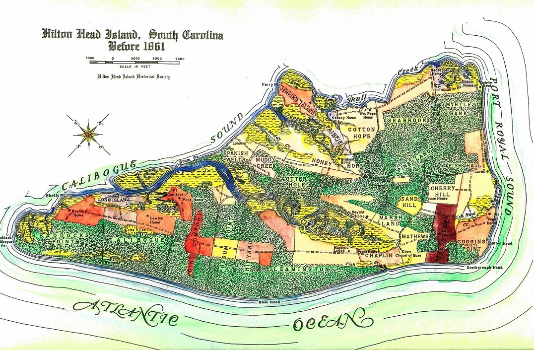
Hack, “Hilton Head Island, South Carolina, before 1861”
Bibliography –
Peeples, An Index to Hilton Head Island Names
Additional Information:
Lancelot Bland and Richard Bland leased portions of Lots 17, 18 and 21 of Bailey’s Barony as shown on Dr. Mosse’s 1783 Survey. When Richard married Elizabeth Fenden in March 1769 he placed 1600 pounds currency and six slaves in trust for Elizabeth with John Cheney and Benjamin Parmenter as Trustees. Richard sold 600-acre Grass Lawn Plantation to William Pope, Sr. who willed it to his son, Richard R. Pope. Richard Bland’s will was proved on 10 May 1776. Lancelot Bland’s will of 15 December 1777 left 2/3 of his estate to Elizabeth Read, daughter of his brother George Bland, and the remainder to his brother Richard’s two children, Richard and Elizabeth Bland.
- Peeples, Robert E.H., An Index to Hilton Head Island Names (Before the Contemporary Development), p. 4.
Bona Plantation
Fast Facts:
Location – Lots 4 and 22, Bayley’s Barony. Land later incorporated into Folly Field and Marshlands Plantations.
Owner – Jacob Bona, a member of the Revolutionary War party, the Bloody Legion in 1781
Maps – Mosse, Hilton Head Island, 1783. Lots 4, 22
Bibliography –
Peeples, An Index to Hilton Head Island Names
Braddock's Point Plantation
Fast Facts:
General Information –
• Location – southern end of the island, Lots 46 and 47 of Bayley’s Barony.
• Origin of name – Both the promontory at the junction of Calibogue Sound and the Atlantic Ocean and Braddock’s Point Plantation were named for David Cutler Braddock, Captain of the Scout Boat maintained by the Colony of South Carolina as a lookout against the Spaniards from 1740 until the 1763 Treaty of Paris.
• See Also Stoney-Baynard Plantation
Owners –
• Leased by John Gambol and James Gray.
• John Mark Verdier – bought Lot 46 of 397 acres 20 April 1785 (?) for 600 pounds from Peter Bayley.
• In 1776 Captain John Stoney (1757-1821) bought the 1000 acres from Beaufort merchant John Mark Verdier and, around 1793, began building the mansion house whose ruins can be seen today.
• Captain James Stoney (1772-1827), his son, inherited the property.
• Dr. George Mosse Stoney next inherited the property.
• “Saucy Jack” Stoney given the plantation in 1838.
• In 1845 William Eddings Baynard purchased the heavily mortgaged property from the bank for $10,000.
• Catherine Adelaide and William Eddings Baynard inherited in 1849.
• Redeemed by sons after confiscation. (See also Spanish Wells)
• In 1893 Elizabeth Baynard Ullmer filed suit against the other heirs to establish the claim of the children of the deceased Ephraim to share in the estate. The court ordered the land sold to satisfy her claim, and in 1894 Braddock’s Point and Spanish Wells were bought by Will Clyde.
• William P. Clyde (1894)
• Roy A. Rainey (1919)
• Thorne and Loomis (1931)
• Hilton Head Company (1951)
Land –
• 1000 acres
• Crops: Sea Island cotton, corn, peas, sweet potatoes
Maps –
Hack, “Hilton Head Island, South Carolina, before 1861”
Mosse, “Hilton Head Island, 1783. Lots 46, 47”
Bibliography –
Peeples, An Index to Hilton Head Island Names.
The Museum of Hilton Head, The Stoney-Baynard Ruins, a Self-Guiding Walk.
Bull Plantation
Fast Facts:
Location – North of Broad Creek. Lots 12, 13, 14, and 15 of Bayley’s Barony
Owners –
- Thomas Bull, principal holder.
- Later constituted the bulk of Stoney’s 944-acre Otterburn Plantation.
Maps – Mosse, “Hilton Head Island 1783. Lots 12, 13, 14, and 15”
Bibliography –
Peeples, An Index to Hilton Head Island Names.
Additional Information:
The 1783 Mosse Survey shows planter Thomas Bull as principal holder of Lots 12-15 of Bayley’s Barony, constituting the bulk of what became Stoney’s 944-acre Otterburn (later Otter Hall and Otter Hole) Plantation on the north side of Broad Creek. St. Helena’s Parish Register shows the burial on Hilton Head Island of Arthur Bull, Christmas Day 1757.
- Peeples, Robert E.H., An Index to Hilton Head Island Names (Before the Contemporary Development), p. 6
Calibogia (Lawton) Plantation
Fast Facts:
General Information –
- Location – Lots 40-44 of Bayley’s Barony, reaching from the Atlantic Ocean to Broad Creek.
- Other names – Calibogue, Lawton’s
Owners –
- George and Ann Barksdale
- Thomas Henry Barksdale
- Martha Sarah Stoney Barksdale Lawton. Martha Lawton also inherited Skull Creek Plantation and Baldwin Plantation. The combined holdings were known as Lawton’s.
- Joseph Lawton, her husband
- Samuel George Lawton, their son, inherited and was forced to mortgage it in order to redeem it under the Redemption Act.
- Harriet Brooks Lawton, his wife, bought the property in 1889 when he sold it at public auction to satisfy its mortgage holder.
- William Clyde purchased it from her March 1889 for $4,000.
- Ray Rainey
- Thorne and Loomis, 1931
Land – 1820 acres
Slaves – 156 slaves
Maps –
Hack, “Hilton Head Island, South Carolina, before 1861”
Mosse, “Hilton Head Island 1783, Lots 40-44”
Bibliography –
Holmgren, Research on Hilton Head Island, 1956-ca. 1975
Holmgren, Hilton Head, A Sea Island Chronicle
Peeples, An Index to Hilton Head Island Names
Additional Information:
38BU1162
Sea Pines Plantation
The Lawton’s Calibogia Plantation consisted of 1,820 acres and stretched from Broad Creek to the Atlantic Ocean. “Calibogia”, which consisted of Lots #40-44 of Bayley’s Baroney, was inherited by Martha Sarah Stoney Barksdale at the death of her husband Thomas Henry Barksdale in 1832. Mrs. Barksdale married her first cousin, Reverend Joseph Alexander Lawton, in 1836. It was about this time that they built a house and Baptist chapel on this plantation.
In 1889 the Lawton’s daughter-in-law, Harriet Brooks Lawton, bought Calibogia Plantation at public auction.
- S.C. Institute of Archaeology and Anthropology initial listing
Reverend Joseph Lawton and Martha, using funds generated from the operation of Martha’s Calibogia Plantation, bought 1205 acres in Barnwell District (near present Allendale)…and built Rose Lawn Plantation. Then they built a home and a Baptist Church on Calibogia…to convert his wife’s slaves with the aid of his uncle, Reverend Winborn Asa Lawton. Their son, Samuel, inherited the plantation now known as Lawton’s. It was seized by William Henry Brisbane’s Direct Tax Commission but Samuel was able to borrow the money to redeem it. When he was forced to sell it at public auction in 1889 to satisfy the mortgage holder his wife, Harriet Brooks Lawton, bought it. She eventually sold it to William Clyde at a profit.
Then in1951 Jane Lawton’s husband, Olin T. McIntosh, became one of the principals of the Hilton Head Company…A decade or so later, Alene Lawton Wyman’s granddaughter, Mary, married Charles Fraser, (then) president of Sea Pines Company, Inc. which includes all of Martha Lawton’s Calibogia Plantation.
- Peeples, Tales of Anti Bellum Hilton Head Island Families, p. 10, 14
“Joseph Lawton married Martha Sarah Stoney Barksdale, widow of Thomas H. Barksdale, in 1836 and thereby acquired rights for himself and his heirs to both Barksdale and Stoney property in the marriage settlement. The heirs were Samuel Lawton, son of Martha and Joseph, and an adopted daughter Josephine Pohill, and they were able to regain the land under the Redemption Act. Samuel was forced to sell it, however, to pay the mortgage, and Harriet B. Lawton bought it at public auction in 1889. She sold it to Clyde for a small profit, and Thorne and Loomis became owners in 1931. The land included a marshy wooded area that has been marked “Sanctuary” on maps of Colonial times and is still a wildlife refuge.”
(Part of this is now the Nature Preserve on Sea Pines. The lakes in the preserve mark the area of rice fields and their water retention ponds. This was the only plantation on Hilton Head to grow rice.)
- Holmgren, Virginia C., Hilton Head, A Sea Island Chronicle, p. 130
“Lawton Plantation was redeemed upon payment of $600.47 in back taxes.” Julia Benedict and Eliza Ann Summers, teachers assigned to Hilton Head by the American Missionary Association, lived and taught at Lawton Plantation in 1867. Their homes were in Woodbury, Connecticut.
- Martin, Josephine, editor, “Dear Sister” Letters Written on Hilton Head Island, 1867, p. 102
“The house itself is a story and a half as most of the plantation houses are in this country. It has four rooms on the first floor, all large and pleasant, with a hall running through the center of it and stairs going up out of it. Two rooms upstairs and a wide piazza extends across the front. This house also is built up on posts like the rest of them. A very nice cistern of water is just back of the house.” She states that about fifty ‘quarters’ surround the house.
- Martin, p. 10
“In February 1867 Lawton Plantation was still in U.S. Government hands…Sunday School in the Praise House…The Praise House at Lawton was also used as the school house…The first Lawton School was established by the American Missionary Society in the fall of 1862 and a school had continued there… January 1867… out of a total of 76 pupils were classified as learning their alphabet or reading in primers…average attendance of 40 children in the Sunday School.”
- Martin, p. xxii
The Lawton Place adjacent to Baynard to the east separated by drainage ditch. About four miles from Braddock’s Point.
- Trinkley, Chicora Foundation Research Series #24, Preliminary Historical Research on the Baynard Plantation, Hilton Head Island, Beaufort County, South Carolina, p. 15
(Source material listed in survey)
Braddock’s Point (Baynard) bounded by ….land late of Lawton known as “The Sister’s Place”
- Trinkley, p. 17
When James Stoney died February 10, 1827 his brother, John acquired the land.
- Trinkley, p. 10-11
After the fall of Hilton Head Samuel G. Lawton filed claim for a Dwelling house of six rooms, kitchen, corn house 22′ x 50′, stable 25′ x 30′, gin house 35′ x 40′, servants house, store room, smoke house, boat house, two good barns, two old barns, sixteen negro houses, blacksmith shop, total value of $4,000. Live stock and other goods listed on page 17 of Survey. (There is no mention of the chapel Joseph Lawton built or of an overseers house although this was not the Lawton’s primary residence.)
- Trinkley, Chicora Research Series 17, Archaeological Survey of the Barker Field Expansion Project, Hilton Head Island, Beaufort County, South Carolina
(Source material listed in survey)
The name used by Martha Sarah Stoney Barksdale Lawton for her 1820 acre plantation, composed of Lots 40-44 of Bayley’s Baroney, reaching from the Atlantic Ocean to Broad Creek, was Calibogia Plantation. There she and her second husband (and first cousin), Rev. Joseph Alexander Lawton, built a home as well as a short-lived Baptist Church. Details of the plantation’s operations may be found in The Lawton Papers in the South Caroliniana Library. It was inherited by their son, Samuel George Lawton, who was forced to mortgage it in order to redeem it under the Redemption Act. In 1889 when he sold it at public auction to satisfy its mortgage holder, his wife, Harriet Brooks Lawton, bought it, eventually selling it to William Clyde at a profit.
- Peeples, Robert E.H., An Index to Hilton Head Island Names (Before the Contemporary Development), p. 6
Capers Plantation
Fast Facts:
General Information – Location – Lot 2 of Bayley’s Barony, ultimately incorporated into Grass Lawn Plantation.
Owners – Richard Capers of the St. Helena family.
Land – 266 acres.
Maps – Mosse, “Hilton Head Island, 1783, Lot 2”
Bibliography–
Peeples, An Index to Hilton Head Island Names
Additional Information:
The well known St. Helena’s Island family of Capers was represented on Hilton Head by Richard Capers who held a 266-acre plantation, Lot 2 of Bayley’s Barony as indicated on the 1783 Mosse Survey, land ultimately incorporated into Grass Lawn Plantation.
- Peeples, Robert E. H., An Index to Hilton Head Island Names (Before the Contemporary Development), p. 7
Chaplin's Plantation
Fast Facts:
Location – on the Atlantic between Mathew’s Folly Field and Pope’s Leamington Plantations, now called Palmetto Dunes.
Owners –
- Benjamin Guerard
- John Hanahan (See Hanahan Holdings)
- Stoney, 1805
- William Fripp Chaplin (1767-1830), in 1820. Shortly thereafter he purchased 400-acre Marshlands Plantation from the estate of Thomas Webb.
- Both estates were entirely lost to the Chaplin family at the confiscation.
- Redeemed in 100-acre plots by 8 Negroes with Adam Green as Trustee on April 7, 1876 for $36.25 each.
- Thorne and Loomis purchased from heirs 1938. (Sand Hill was included by mistake in this sale).
Land – 400 acres.
Maps – Hack,”Hilton Head Island, South Carolina, before 1861″
Bibliography –
- Holmgren, Research on Hilton Head Island
- Holmgren, Hilton Head, A Sea Island Chronicle
- Peeples, An Index to Hilton Head Island Names
Additional Information:
“The Chaplins owned land on St. Helena Island and which of the brothers came to Hilton Head is not clear. Their plantation between Leamington and Mathew’s contained 400 acres which was increased to 800 with the purchase of Marshlands, adjacent inland to their original purchase. Both estates were reserved by the Federal government for sale to Negroes and were not redeemable.”
- Holmgren, Virginia C., Hilton Head, A Sea Island Chronicle, p. 125
“From the Chaplin family history it is not clear just which Chaplin bought the 400 acre ocean front plantation bearing the family name and later added 400-acre Marshland Plantation.” (William, John or Benjamin of St. Helena’s)
- Peeples, Robert, Tales of Ante Bellum Hilton Head Families, p. 11
c. 1920 “…. families in the area included Christophers, Browns, Driessen, Ford, Ferguson, Porter, Simmons, Burks, Kellerson, Singleton, Green”
- Grant, Moses, Looking Back, p. 14
John Chaplin arrived in Carolina in April 1672. Chaplin Creek near the confluence of the Stono and Kiawah Rivers marking the area of his residence. His son, John Chaplin, Jr., married Phoebe, daughter of John Ladson, and settled on St. Helena’s Island before 1716. Their grandson, William Fripp Chaplin (1767-1830) in 1820 owned 400-acre Chaplin Plantation on the Atlantic between Mathew’s Folly Field and Pope’s Leamington Plantations. Shortly thereafter he purchased 400-acre Marshlands Plantationfrom the estate of Thomas Webb. Both estates were lost to the family at the time of confiscation. The name Chaplin Plantation still endures.
- Peeples, Robert E.H., An Index to Hilton Head Island Names (Before the Contemporary Development), p. 7
Cherry Hill Plantation
Fast Facts:
General Information –
- Location – north of Folly Field and Grass Lawn Plantations and south of Pope’s Fish Haul Plantation. Includes 250 acres of Lot 1 of Bayley’s Barony.
- Other names – Peeples’ Index notes that it was probably once called Baldwin Plantation.
- See also Baldwin Plantation
Owners –
- Kirk family Island seat until confiscation in 1861.
- W. D. Brown bought its 400 acres in 1876 for $400, selling one acre each to Deacon’s First Hiltonhead Baptist Church (1916) and Queen’s Chapel A.M.E. Church (1888), land still so held.
- Heirs Helen Campbell and Fannie Holmes, Brown and wife having been murdered July 3, 1923.
- Dr. T. E. Oertel bought 51 acres for Osprey Fishing Club on May 30, 1925, sold to Roy Rainey August 1927.
Land – 400 acres
Maps –
- Mosse, “Hilton Head Island 1783, Lot 1”
- Hack, “Hilton Head Island, South Carolina, before 1861”
Bibliography –
- Holmgren, Research on Hilton Head Island
- Peeples, An Index to Hilton Head Island Names
Additional Information:
Off Beach City Road, inland from Fish Haul Plantation
“The Kirk name is the most frequently inscribed on the gravestones of Zion Chapel cemetery…. Two Kirk brothers, John and Rollin, were among the Confederates who made successful raids on the Yankee held island in wartime. There is some indication, but not actual proof, that their residence on Hilton Head was the plantation called Cherry Hill, sold in 1876 to W.D. Brown. The price Brown paid for Cherry Hillwas $400. He sold one acre each to Negro Baptists and Methodists for their churches. After Brown’s murder (see Holmgren, p.121), the land was sold to Roy Rainey, with the exception of 51 acres owned for a few years by the Osprey Fishing Club. Thorne and Loomis took over from both.”
- Holmgren, Virginia C., Hilton Head, A Sea Island Chronicle, p. 129
Area named Brownsville in honor of W.D. Brown who had acquired 400 acres in 1876 from two Confederate brothers, John and Rollin Kirk. The First African Baptist Church, 1863, the oldest existing church on the island, is located here. Queen Chapel AME Church, built around 1892, is also in this area.
- Grant, Moses, Looking Back, p. 15
Cherry Hill Plantation lay to the north of Folly Field and Grass Lawn Plantations and south of Pope’s Fish Haul Plantation. It included the 258 acres of Lot 1 of Bayley’s Barony plus additional acreage. It was probably once called Baldwin Plantation, later becoming the island seat of the Kirk family from whom it was confiscated in 1861. W.D. Brown bought its 400 acres in 1876 for $400, selling one acre each to Negro Baptists and Methodists for their churches, land still so held.
- Peeples, Robert E.H., An Index to Hilton Head Island Names (Before the Contemporary Development), p. 7.
Coggins Point Plantation
Fast Facts:
General Information –
- Location – northeastern corner of the Island.
- Other names – Colginse Point, possibly for a promontory in Virginia where the Pope family earlier resided.
Owners –
-
Edmund Ellis and Samuel Green, jointly given an original Royal grant dated 7 May 1762 (SC Archives Royal Land Grants, vol. X, p. 220).
-
Edmund Ellis took Fish Haul as his portion (see also), and sold it to Samuel Green in April 1763.
-
Sarah and Susannah Green inherited from their father in his will of 24 February 1767.
-
William Pope, Sr., second husband of Sarah, received Coggins Point through the marriage.
-
Pope family made this their principal seat until confiscation. Mansion built by Squire William Pope, Jr., in 1806.
-
Federal Government took possession Dec.1, 1863. Declared a military reservation (Fort Walker) on Oct 27,1874.
-
Sold by Secretary of War in 1927 for $12,600 possibly to carpetbagger Weiss.
-
Landon K. Thorne and Alfred L. Loomis, 1931.
Land – 800 acres, 321 of which were Fish Haul.
Maps – Hack, “Hilton Head Island, South Carolina, before 1861”
Bibliography –
Holmgren, Research on Hilton Head Island, 1956-ca. 1975
Holmgren, Hilton Head, A Sea Island Chronicle
Peeples, An Index to Hilton Head Island Names
Porcher, The Story of Sea Island Cotton
Additional Information:
Colginse Point Plantation
Port Royal Plantation
Also see Fish Haul Plantation, Fort Walker
Coggins Point was the plantation seat of Squire William Pope (1788-1862). On the northeast corner of the island Squire Pope built a two-story frame residence on a high brick foundation in 1806, when he married Ann Scott of neighboring Grass Lawn Plantation. In 1816 Pope married his cousin, Sarah Lavinia Pope. The plantation contained 806 acres. Pope served in the South Carolina House of Representatives (1810-1814, 1816-1818, 1850-1852) and in the South Carolina Senate from 1822-1832. In addition to Coggins Point Plantation Pope owned Skull Creek and Point Comfort Plantations on Hilton Head and Cresant Plantation near Bluffton. When Thomas Barksdale died in 1832, court action on the part of relatives necessitated the sale of Skull Creek Plantation. Pope bought 1,000 acres along Skull Creek, including Barksdale’s home, renaming the property Cotton Hope. It became his island seat. The 1860 agricultural census listed Squire Pope as owning 200 slaves in St. Luke’s Parish. The Coggins Point house was used as headquarters of the Department of the South during the Civil War. By 1864 a signal tower had been built atop the hip-roofed structure and the spacious double verandahs enclosed to provide more room. The signal tower was placed on the roof by Lt. Keenan. (Photos in Carse, Holmgren and Museum collection) Both Fort Walker and Fort Sherman are located on Coggins Point Plantation.
- South Carolina Institute of A & A original listing
“The first Popes on Hilton Head were probably William and Sarah. In 1791 they sold 365 acres of their Coggins Point land to the Scotts keeping the 803 acres that would remain in the Pope family until confiscation.”
- Holmgren, Virginia C., Hilton Head, A Sea Island Chronicle, p. 130
“Fred C. Hack, president of The Hilton Head Company, has offered to deed the site of the Coggins Point plantation, home of Squire William Pope (1788-1862), adjacent to the site of Fort Walker, to the Hilton Head Historical Society on condition that the house be restored for use as a museum.”
- The Island Packet, January 27, 1972
“The word (of Pope’s house) comes in the diaries of young soldiers, one of whom wrote, ‘When our men landed on Hilton Head, the Negroes guided them to the Rebel officer’s headquarters, which was on the Pope Plantation. Here they found a very fine library. There were besides the books, complete files of old papers, some dating as far as 1812. Hard wasn’t it, to have all these things destroyed?’ This was written by General Saxon’s quartermaster who would set up headquarters there. Another recorded “abandoned in such haste that the horses in the stable were left behind and General Drayton’s own charger, a fine handsome bay horse…was captured here and became the favorite horse of General Stevens.
- Islander Magazine, December 1977; Nancy Cathcart
No one came to redeem the Pope house (after the war). It is said the house was eventually dismantled and sold in Beaufort for scrap lumber. Coggins Point was held as a military reservation until 1927 when it was sold by the Secretary of War. Like a mirage, the Squire’s house is once again rising at Fort Walker beside the banks of Fish Haul Creek. Talented Wayne and Ceil Edwards….are today rebuilding an exact replica of Squire William Pope’s Plantation house, now within the borders of Port Royal Plantation. They are building as close as possible to the former location.”
c. 1920 “…families included Bryan, Wright, Barnwell, Bligen, Fuller, Jones, Small, Young, Ford, Joiner, Miller, Orage, Lawyer”
- Grant, Moses, Looking Back, p.14
Called Colginse Point Plantation in the will of Samuel Green of 1767; left to Green’s daughters Sarah and Susannah. Peeples claims Sarah married William Pope, Sr.
- Peeples, Robert, Tales of Ante Bellum Hilton Head Families, p. 2
“…the Federal government had still kept possession of the 803 acres at Coggins Point where Fort Walker was located.” During the Spanish American War, the fort was reactivated in 1898 and a new type of dynamite gun was installed. Abandoned in 1899 the land remained Federal property. In 1917 the barracks were reactivated and big guns were put in place along the shore. A submarine watch was kept until the end of World War II.
- Holmgren, p. 119-120
The valuable 800-acre Coggins Point Plantation at the northeastern corner of the island was part of an original Royal Grant dated May 7, 1762 (SC Archives – Royal Grants Volume X, p. 220) jointly to Edmund Ellis and Samuel Green. Samuel Ellis took Fish Haul which he and his wife, Elizabeth, sold to Samuel Green (321 acres) in April 1763 who made it his place of residence. In his will of February 24, 1767 Samuel Green left Colginese Point Plantation to his daughters Sarah and Susannah. Sarah Green, named for her mother Sarah Norton Green, married Thomas Tucker and then William Pope, Sr. carrying to him her Coggins Point Plantation which became a principal seat of the Pope family until confiscation. Reporters of the Battle of Port Royal Sound in 1681 described ‘”a rich old plantation mansion”, the home of William Pope, Jr., the redoubtable ‘Squire Pope’, built in 1806 when he married Ann Scott of Grass Lawn Plantation. Colginese Point may have been named for a promontory in Virginia where the Pope family earlier resided.
- Peeples, Robert E.H., An Index to Hilton Head Island Names (Before the Contemporary Development), p. 8
Conyers Plantation
Fast Facts:
General Information – Location – Scull Creek
Owners –
- Gentleman named Conyers, in the mid-eighteenth century.
- Mary Ann Ladson, granddaughter of Conyers and wife of Captain John Talbird inherited. Conyers and Ladson jointly brought a cargo of slaves directly to the Island and reputedly did very well on the venture.
Bibliography –
Peeples, An Index to Hilton Head Island Names
Additional Information:
During the mid-eighteenth century a gentleman named Conyers, claiming to be a descendent of Sir John Conyers, Commander of the Tower of London during the reign of King Charles I, had a plantation on Skull Creek adjoining that of his Ladson son-in-law. Conyers and Ladson joined the purchase of a cargo of African slaves brought directly to the island by a Boston based ship and reputedly did very well on the venture. But Conyers was accidentally drowned while fishing, the spot long known as ‘Conyers Hole’. At the death of his widow, his plantation was inherited by their granddaughter, Mary Ann Ladson, wife of Captain John Talbird.
- Peeples, Robert E. H., An Index to Hilton Head Island Names (Before the Contemporary Development), p. 9
Cotton Hope Plantation
38BU1166; 38BU96, 833, 1290 (Shell middens)
Also see Skull Creek Plantation 38BU834 (main house area); 38BU62 (tabby structure), Squire Pope Road 38BU90,96 (slave row)
Fast Facts:
General Information –
- Location – north of Fairfield Plantation along Scull Creek.
- When Island planter Thomas Henry Barksdale died childless in August 1832, leaving his widow, Martha Sarah Stoney Barksdale of the Otterburn Plantation family, as sole heiress, several of his relatives brought court action against the widow and won handsome cash settlements which necessitated the sale of Barksdale’s 2600-acre Scull Creek Plantation.
Owners –
- Squire William Pope bought 1000 acres, including the handsome Scull Creek Plantation House, renaming it Cotton Hope Plantation and made it his Island seat; his son, William John Pope and his family being then installed at Coggins Point.
- William Seabrook apparently purchased the other 1600 acres.
- Leased by federal government during the Civil War.
- Eliza Woodward, a Pope heir, redeemed the property Jan 4, 1887.
- She sold her interest to John E. Woodward, another heir, March 8, 1889, who deeded the property to his wife Mary.
- Mary began to sell off the property in small lots to Hilton Head freemen. (See Hilton Head Land Owners, Some Nineteenth Century Owners)
- Heirs sold about 45 acres in small plots of Negroes and in larger plots to Roy Rainey.
- Thorne and Loomis, 1931
See also Seabrook Plantation and Skull Creek Plantation.
Land – 1000 acres
Maps – Hack, “Hilton Head Island, South Carolina, before 1861”
Bibliography –
Trinkley, Archaeological Excavations at 38BU96, Portion of Cotton Hope Plantation
Holmgren, Research on Hilton Head Island, 1956-ca. 1975
Holmgren, Hilton Head, A Sea Island Chronicle
Peeples, An Index to Hilton Head Island Names
Additional Information:
Built by Thomas Henry Barksdale, c. 1815, the two story clapboard house on a tabby foundation was approached by a double avenue of magnolia trees. Barksdale died childless in 1832, leaving his widow, Martha Sarah (Stoney) Barksdale, as the sole heiress. Several of his relatives instituted court action against the widow and won cash settlements which necessitated the sale of Barksdale’s 2,600 acre Skull Creek Plantation. William Seabrook bought 1,600 acres and William Pope, Jr. known as Squire Pope, bought the remaining 1,000 acres along Skull Creek, including the Barksdale’s Skull Creek Plantation house. Squire Pope renamed the plantation Cotton Hope and made it his home.
- South Carolina Institute of A & A original listing
Squire Pope’s daughter, Mrs. Alsop Park Woodward, regained ownership of the plantation in 1874. In the nine years following the Civil War, the Reverend Thomas Howard conducted the first black school on Hilton Head in the best front parlor of Cotton Hope house. (This fact is disputed by Holmgren (p.99) stating “Apparently one Negro school had been already opened on the island in January by Mr. Barnard K. Lee, who came in advance of the sponsored group.”)
Stephen Weld, aide to General Wright, went on a foraging mission and “At Pope’s Cotton Hope Plantation, which he thought the nicest on the island, it was the same story,” plundered by the negroes and the soldiers, leaving “only a piece of a clock as a memento”.
- Holmgren, Virginia C., Hilton Head, A Sea Island Chronicle, p. 95
“Cotton Hope, sometimes called Skull Creek Plantation, also belonged to the Honorable William Pope and boasted a fine house whose tabby wall foundations still stand not far from the road to Seabrook Landing.” (This was in 1959)
“Lawyers acting for John E. Woodward, Eliza’s son and heir, redeemed Cotton Hope in 1887. (John was William’s grandson) The heirs sold Cotton Hope in small plots to Negroes and in larger plots to Roy Rainey. ..and eventually went to Thorne and Loomis.”
- Holmgren, p. 131
38BU96 represents an outlying slave settlement associated with the Skull Creek Plantation during the late colonial period and the Cotton Hope Plantation during the antebellum period. 38BU833 is a shell midden of unknown association eroding from the creek bank on or north of parcel 4. It is heavily disturbed by construction as well as erosion. Significant portions of the site contain buried intact shell middens both along the bank and further inland. The site is recommended for inclusion on the National Register of Historic Places. Both sites are about 1 1/2 miles north of US 278 in Hilton Head Plantation. 38BU1290 is along Skull Creek in the western portion of parcel 9. The area is heavily disturbed by previous grubbing activities. Artifacts are sparse and the area is not deemed eligible for the National Register.
- Adams, Chicora Foundation Research Contribution 74, Archaeological Survey of Parcels 4 and 9, Hilton Head Plantation, Hilton Head Island, Beaufort County, South Carolina (Source materials listed in survey)
The tabby foundation noted by Holmgren is now known to have been an out building not the main house. The standing tabby structure is of probable industrial or storage use. It is in good condition and of high integrity. Its architectural features are unique on the island and very rare in the region. This is recommended for the National Register at the level of state significance. The estate of William Pope made a claim for a ‘plantation’ of 201 slaves and crops, buildings, furniture, animals, wagons, boats, etc. of about $30,000. Cotton Hope’s main house furnishings were valued at $1,000 and the library contents at $2,000. In 1877 Cotton Hope is listed as having 1250 acres – 400 cultivated, 150 cleared but not cultivated and 700 of woodlands. The site of the 19th century slave row is of undeveloped, large domestic scatter. Being one of the better preserved slave sites it is recommended for the National Register of Historic Places.
- Chicora Research Series 13, Archaeological Testing of Six Sites on Hilton Head Island, Beaufort County, South Carolina, p. 29, 70
- also Archaeological Survey of Parcel 9, Hilton Head Plantation, Hilton Head Island, Beaufort County, South Carolina
An 1862 plat shows in detail the layout of the plantation. From about 1861 to 1874 the property was leased, both to overseers and eventually to tenants, for cotton farming. Shortly after the property was redeemed by Pope heirs, the plantation was subdivided and sold to freedmen. A portion of Cotton Hope was maintained intact and eventually became part of Hilton Head Plantation. The remainder of the land is still divided into small parcels owned by primarily the island’s Black residents.
The tabby ruins of a building connected to Cotton Hope Plantation can be seen to the right of Squire Pope Road just before Gum Tree Road.
- Islander Magazine, January1972
When island planter Thomas Henry Barksdale died childless in 1832, leaving his widow, Martha Sarah Stoney Barksdale of the Otterburn Plantation family, as sole heiress, several of his relatives brought court action against the widow and won handsome cash settlements which necessitated the sale of Barksdale’s 2600 acre Skull Creek Plantation. Squire Pope bought 1000 acres lying north of Fairfield Plantation along Skull Creek, including the handsome Skull Creek Plantation house with its double avenue of Magnolia Grandiflora marching down to the creek landing. Squire Pope not only renamed it Cotton Hope Plantation but made it his island seat, his son, William John Pope and his family being then installed at Coggins Point. Skull Creek Plantation house was built by Thomas Henry Barksdale shortly after August 1813 when the British landed in force and burned most of the island’s residences. It stood two stories above a tabby foundation basement floor, the ruins of which are extant.
- Peeples, Robert E.H., An Index to Hilton Head Island Names (Before the Contemporary Development), p. 9
Cowen Plantation
Fast Facts:
General Information – Location – Lots 34 and 36 of Bayley’s Barony.
Owners –
- Thomas or Jacob Cowen (probably), representative of the St. Helena’s Island family.
- Eventually incorporated into Shipyard and Possum Point Plantations.
Land – 232 acres in Lot 34, 314 acres in Lot 36.
Maps – Mosse, “Hilton Head Island, 1783. Lots 34 and 36”
Bibliography –
Peeples, An Index to Hilton Head Island Names
DeSaussure Plantation
Fast Facts:
General Information – Location – Lot 35 of Bayley’s Barony
Owners –
- Held by Daniel DeSaussure during the pre-Revolutionary era
- The lot was later sold to J. Berwick and passed into contemporary Shipyard Plantation.
Land – 312 acres
Maps – Mosse, “Hilton Head Island, 1783. Lot 35”
Bibliography –
Peeples, An Index to Hilton Head Island Names
Additional Information:
During the pre-Revolutionary era a 312-acre plantation, Lot 35 of Bayley’s Baroney, was held by Daniel DeSaussure, son of the French Huguenot immigrants, Henri and Magdale Brabant DeSaussure of Lausanne who settled in Beaufort District in 1731. It was later sold to J. Berwick and passed into contemporary Shipyard Plantation.
- Peeples, Robert E.H., An Index to Hilton Head Island Names (Before the Contemporary Development), p.11.
Eden Plantation
Fast Facts:
General Information – Location – on the area along Scull Creek later known as Fairfield Plantation, per a map of 1777.
Owners – Apparently the plantation residence of William Eden. Still a landholder in 1793.
Bibliography –
Holmgren, Hilton Head, A Sea Island Chronicle
Peeples, An Index to Hilton Head Island Names
Additional Information:
1777 map of the island shows a plantation named “Eden” covering the area along Skull Creek later known as Fairfield Plantation. This was apparently the plantation residence of William Eden, widower, who married in May 1753 Marseil Margaret, daughter of Philip and Eleanor Delegall.
- Peeples, Robert E. H., An Index to Hilton Head Island Names (Before the Contemporary Development), p. 12
Ellis Plantation
Fast Facts:
General Information – Location – stretching eastward along Port Royal Sound from Myrtle Bank toward the Atlantic, evidently not part of Bayley’s Barony..
Owners –
- John Barnwell, December 10, 1717, probably Hilton Head’s first settler
- Katherine Barnwell Bryan who died in 1740.
- Edmund Ellis and Samuel Green purchased jointly as 900 acres.
- Sons Thomas and Edmund Ellis inherited 685 acres from their father; eventually sold entire holdings and moved to inland plantations.
Land – 500 or 2000 acres
Bibliography –
Holmgren, Hilton Head, A Sea Island Chronicle
Peeples, An Index to Hilton Head Island Names
Addtional Information:
After the death of Katherine Barnwell Bryan in 1740, her 500-acre plantation, stretching eastward along Port Royal Sound from Myrtle Bank towards the Atlantic, was sold jointly to Edmund Ellis and Samuel Green as 900 acres. Edmund Ellis in his January 5, 1775 will left his 685-acre island plantation to be divided between his sons Thomas and Edmund. They eventually sold their entire island holdings and settled on inland plantations which were eventually incorporated into present Chelsea Plantation. Kathryn Bryan’s “500-acre plantation” eventually proved to contain nearly 2000 acres, including her brother John Barnwell, Jr’s 500-acre Fish Haul.
- Peeples, Robert E. H., An Index to Hilton Head Island Names (Before the Contemporary Development), p. 13
Fairfield Plantation
Fast Facts:
General Information –
-
Location – plantation stretching from Skull Creek to Jarvis Creek and from Cotton Hope to Jenkins Island
-
Other names – Stoney
Owners –
-
Captain John Gascoigne apparently purchased part of the original Bayley’s Barony William Eden.
-
William Eden.
-
Benjamin Guerard, new Governor of South Carolina, who also leased Lot 19 and parts of Lots 18 and 22, per 1783 Moose Survey.
-
Captain Jack Stoney soon thereafter purchased the property (prior to 1827) and his family held it until confiscation.
-
R. C. McIntire redeemed part on Apr. 7, 1876; also part by Henry and Alfred Hudson and some Negroes.
-
Resold to F. R. Klem in 1885 by McIntire heirs, who resells in small plots.
• Roy Rainey buys from Simon Grant heirs, 1928. -
Thorne and Loomis.
-
Hudsons kept most of their acreage.
Land – 350 acres
Maps –
Mosse, “Hilton Head Island, 1783”
Hack, “Hilton Head Island, South Carolina, before 1861”
Bibliography –
Holmgren, Research on Hilton Head Island, 1956-ca. 1975
Holmgren, Hilton Head, A Sea Island Chronicle
Peeples, An Index to Hilton Head Island Names
Additonal Information:
38BU1166, 38BU63
Also known as Stoney’s Place
In the post-Revolutionary period the Stoneys were the largest landowners on the island, owning 5,115 acres including 350-acre Fairfield.
- Peeples, Tales of Ante Bellum Hilton Head Families, p. 4
Property was owned by Joseph Stoney at the time of the Civil War. There is mention of Federal troops being stationed at the plantation. In 1862 a survey map shows a main house, orchards, slave row and support buildings. In 1867 the plantation consisted of a mansion, quarters, and a school house on 350 acres of cultivated land, 150 acres of extra cleared land and 500 acres of woodland. 150 people lived there. The slave row overlies prehistoric deposits 38BU63 and is recommended for National Register of Historic Places.
- Chicora Series 13, Archaeological Testing of Six Sites on Hilton Head Island, Beaufort County, South Carolina, p. 32 (Source materials listed in survey)
The 38BU1166 site covers an area of about 4.4 acres. The site integrity is high and is recommended for the National Register. Part of this is private property.
- Chicora Series 13, p. 73
Rev. Thomas Howard, a preacher and teacher under The Port Royal Experiment, was assigned to Hilton Head. He and Mr. Strong, who was to oversee the farming, were assigned to the Widow Stoney’s House, which would be Fairfield Plantation on Skull Creek……two officers of a Pennsylvania regiment were already established. Letters by another teacher describe the house. “The plantation houses are all built of hard pine, which is handsome on the floors, but the rest of the woodwork is painted….The walls are always left white….clapboards are unknown, but hard pine boards a foot or more wide are put on in the same manner and everything outside is whitewashed. The place is very attractive looking, with grape vines and honeysuckle, and pinewoods near. The house is raised high from the ground, as all are here, and boarded loosely underneath. The rooms are twelve feet high and the lower story more than twelve feet from the ground. Some rooms are eighteen feet square….There’s a circle of orange trees ’round the house and roses in abundance, but no grass. The quarters are a fourth of a mile from the house and a praise house stands near them.” Howard makes mention of the Rose of Sharon bushes growing almost as high as trees about the extensive grounds and the wild blackberries that grew everywhere.
- Holmberg, Sea Island Chronicle, p. 100
“After confiscation part of Fairfield was bought by Henry and Alfred Hudson and inherited by James B. Hudson who was appointed Postmaster in 1923. At the same time (1876) several negroes bought small plots and the balance of 350 acres went to R.C. McIntyre for $350. His heirs sold it to F.R. Klem for $2,000 in 1885. The McDonald Wilkins Company of Savannah leased the cotton fields from 1913 to 1932. (The partners in this concern were M.D. Batchelder, William Keyserling, and G.W. Wilkins.) Rainey picked up almost all of the land not owned by the Hudsons, who still live here, and sold it to Thorne and Loomis.
- Holmgren, p. 133
In 1895 McIntyre’s heirs sold part of Fairfield to a New Englander, W.P. Clyde. (Does this mean they did not sell all of holding in 1885?)
- Holmgren, p. 119, 132
“James B. Hudson, who owned part of Fairfield”…was one of two men on the island who made seafood packing a business. This was in the early 1900’s.
- Holmgren, p. 121
The 350-acre plantation, stretching from Skull Creek to Jarvis Creek and from Cotton Hope to Jenkins Island, was apparently part of the original Bayley’s Barony, sold first to Captain John Gascoigne and once owned by William Eden. In the 1783 survey by Dr. Mosse it was held by Benjamin Guerard, the new governor of South Carolina. Soon thereafter it was purchased by Captain Jack Stoney whose family held it after confiscation.
- Peeples, An Index to Hilton Head Island Names (Before the Contemporary Development), p. 13
Fenwick Plantation
Fast Facts:
General Information – Location – Lot 27 of Bayley’s Barony
Owners – John Fenwick, per the 1783 Mosse Survey. The plantation was later incorporated into Leamington.
Land – 445 acres
Map – Mosse, Hilton Head Island, 1783. Lot 27
Bibliography –
Peeples, An Index to Hilton Head Island Names
Ferguson Plantation
Fast Facts:
General Information – Location – south side of Broad Creek, Lot 28 of Bayley’s Barony.
Owners –
- Estall Laurence, lessee
- Mr. Ferguson, apparently a son of John and Mary Ferguson of St. Helena’s Island, acquired the plantation in 1783.
- Eventually incorporated into Shipyard Plantation.
Land – 316 acres
Map – “Mosse, Hilton Head Island, 1783 Lot 28”
Bibliography –
Peeples, An Index to Hilton Head Island Names
Additional Information:
In 1783 Mr. Ferguson, apparently a son of John and Mary Ferguson of St. Helena’s Island, acquired a 316-acre plantation on the south side of Broad Creek, Lot 28 of Bayley’s Barony, formerly leased by Estall Laurence and eventually incorporated into Shipyard Plantation.
- Peeples, An Index to Hilton Head Island Names (Before the Contemporary Development). p. 14.
Fickling Plantation
Fast Facts:
General Information – Location – stretching from Broad Creek to the Atlantic between Point Comfort and Leamington
Owners –
- William and Samuel Fickling were Hilton Head planters as early as 1798, owning both Possum Point and Shipyard Plantations.
- Samuel Fickling married Elizabeth Davant, daughter of John and Lydia (Page) Davant, heiress of a 300-acre plantation, Lot 38 of Bayley’s Barony. (Lot 38 was purchased by James Davant from Benjamin Bayley 2 Jan 1792 for 90 pounds.)
- Possum Point and Shipyard may have been sold before secession as an 1861 map calls Possum Point Wills (Wells).
- W. D. Brown purchased 465 acres called Ficklings which included Possum Point and 535 adjacent acres at the confiscation.
- Roy Rainey purchased the Possum Point portion from Brown.
- The remainder was sold in plots of 100 to 165 acres, all eventually purchased by Thorne and Loomis.
Land – 2000 acres
Maps –
Mosse, “Hilton Head Island, 1783. Lot 38”
Hack, “Hilton Head Island, South Carolina, before 1861”
Bibliography –
Holmgren, Hilton Head, A Sea Island Chronicle
Peeples, An Index to Hilton Head Island Names
Addtional Informaton:
As early as 1798 William and Samuel Fickling were Hilton Head planters, owning both Possum Point and Shipyard Plantations, more than 2000 acres, stretching from Broad Creek to the Atlantic between Point Comfort and Leamington. Samuel Fickling married Elizabeth Devant (1775-1808), daughter of John and Lydia (Page) Devant, heiress of a 310-acre ocean front plantation, Lot 38 of Bayley’s Barony.
- Peeples, An Index to Hilton Head Island Names (Before the Contemporary Development). p.15
Fish Haul Creek (Drayton) Plantation
Fast Facts:
General Information – Location: along Port Royal Sound
Owners –
- Edmund Ellis and Samuel Green, jointly given an original Royal grant dated 7 May 1762 (SC Archives Royal Land Grants, vol. X, p. 220).
- Edmund Ellis in 1775 left his holdings to his sons Thomas and Edmund.
- Samuel Green took Fish Haul as his portion and left it to his son Samuel and his Colginse Point Plantation to his daughters Sarah and Susannah in his will of 24 February 1767.
- Sarah Green eventually controlled all this property; married William Pope, Sr. after death of husband Thomas Tucker.
- In 1856 400 acres of pine barrens were added in purchase from Daniel Jenkins and Harriet Pinckney.
- Property eventually passed to their son John Edward Pope, likely builder of “Drayton House,” who leaves property to his widow Mary Baynard Edings Pope and daughter Emma Catherine.
- Catherine Emma Pope eventually inherits from her mother Mary Drayton Pope; marries Thomas F. Drayton, of Rephaim Plantation, Bluffton. Fish Hall used as their home.
- Brig. Gen. Thomas Fenwick Drayton of the Confederate Army used family home here as headquarters in 1861. Capt. Percival Drayton, his brother, served in the Union Fleet which participated in the Battle of Port Royal and captured Hilton Head from the Confederate army.
- After confiscation, part was kept by Federal government, part sold to Negroes, remainder redeemed by heirs of Mary Drayton Pope.
- In 1871 heirs began selling in small plots. March Gardner owned about 70 acres, left to son Gabriel, and then to Gabriel’s wife and daughter. Granddaughter Eugenia Heyward inherited and let go to delinquent taxes.
- J. E. Laurence bought part for Roy Rainey about 1930.
- Thorne and Loomis in 1931 purchased in thirteen different transactions.
Land – 1100 acres, 700 were the original Fish Haul Creek Plantation, 400 were Pine Barrens.
Maps – Hack, Hilton Head Island, South Carolina, before 1861
Bibliography –
Holmgren, Hilton Head, A Sea Island Chronicle
Holmgren, Research on Hilton Head Island
Peeples, An Index to Hilton Head Island Names
Peeples, Tales of Ante Bellum Hilton Head Island Families
Porcher, The Story of Sea Island Cotton
Addtional Information:
38BU1152, 38BU805/806
Beach City Road
Also see Coggins Point Plantation, Fort Howell, Fort Walker
The plantation lands acquired jointly by Samuel Green and Edmund Ellis after 1740 stretched from Fish Haul Creek westward along Port Royal Sound. In 1785, Sarah Green Tucker, widow of Thomas Tucker and daughter of Samuel Green, married Captain William Pope and made Fish Haul their primary residence. Emma Catherine Pope married General Thomas Fenwick Drayton in 1832. General Drayton used Fish Haul as his headquarters for the Confederate defenses of Hilton Head Island until 1861. Tabby ruins and a plantation cemetery are all that remain. (198?)
- South Carolina Institute of A & A original listing
“…island planter Samuel Green in his earlier will of 24 February 1767 left his Fish Haul Plantation, where he lived, to his son Samuel…Eventually Sarah Green…became sole heiress to all this and married William Pope, Sr…”
- Peeples, Tales of Ante Bellum Hilton Head Island Families, p. 2
“William Drayton and his wife Mary were owners of 1100 acres, 700 of which were the original Fish Haul Creek Plantation (often called Fish Hall) probably bought from Samuel Green heirs about 1770… (see above entry)…Part of this estate was sold by the Federal government to Negroes and part kept for a military reservation. The remainder was redeemed March 1875 for $407.83 in taxes by the heirs of Mary (Drayton) Pope who had evidently remarried….and they offered to give land for a new cemetery and for a church also if the next-of-kin would remove bodies buried near their home. In 1877 the heirs began selling in small plots and in 1931 Thorne and Loomis bought Fish Haul land in thirteen different transactions.”
- Holmgren, Virginia C., Hilton Head, A Sea Island Chronicle, p. 115
The 1989 Chicora Foundation work on the Fish Haul Slave Row was the first published archaeological documentation of a slave settlement on Hilton Head Island. Three five foot units and some standing tabby chimneys were noted.
Trinkley, Chicora Research Series 28, Archaeological Testing at the Stoney/Baynard Plantation, Hilton Head Island, Beaufort County, South Carolina, p. 16 (Source material noted in survey)
The 38BU806 portion of Drayton’s Fish Haul Plantation slave row (38BU805 in 1986 Chicora work and in 1989 Brockington work), judged to be one of the most significant archaeological sites on Hilton Head. High degree of site integrity and archaeological remains in excellent state of preservation. Recommended as eligible for National Register of Historic Places. Barker Field is about ten acres county owned and operated, managed by Beaufort County Recreation Department.
- Trinkley, Chicora Research Series 17, Archaeological Survey of the Barker Field Expansion Project, Hilton Head Island, Beaufort County, South Carolina (Source material listed in survey)
Colonel John Barnwell received a Royal Grant for 500 acres on December 10, 1717. He named it Fish Haul. His son, John, and wife, Martha, sold it to Edward Ellis, October 24, 1760. In 1838 Thomas F. Drayton married Mary Baynard Pope and they resided with her mother, Mary Baynard Pope, at Fish Haul. (father was John Edward Pope) When Mary died in 1856, Thomas was named administrator of her estate and operated Fish Haul in trust for seven minor Drayton children.
The 1860 slave census shows 52 slaves on Fish Haul. The Agricultural census of 1860 shows 250 improved acres, 450 unimproved, valued at $10,000. Absence of farm animals on the list indicates strongly oriented cotton plantation. Grain and food were raised for local use.
In the 1863 tax sales the property was sold to the Federal government for $3,000. The listing of 1300 acres suggests the combining of Fish Haul and the adjacent Pinelands Plantation. Drayton is recorded as providing “substantial slave quarters in good condition” and the main house as “lordly”. Photographs from 1862 substantiate these statements.
In 1862 about 200 acres was used to create the freedmen’s village of Mitchelville.
Fish Haul was rented to Bacchus Singleton, in trust for himself and those living on the land who paid their part of the rent of $220 in 1862. The rental was subject to military occupation and half of the mansion house was held for a school. Certain restrictions applied such as only half of the arable land could be cultivated in any given year – the other half being fallow. The government could take a lien on the crop guaranteeing payment of rent, no one living on the property could be forced off, all work was shared equally and no one could live in the mansion house.
In 1867 the plantation was home to 120 blacks. The rent was $90.
By 1868 the land was rented to Summer Christopher. In 1871 the rental was $140 and no longer “in trust”. After 1871 the land was no longer rented.
On April 17, 1875 the heirs of Mary Baynard Pope paid $407.83 for about 1300 acres including Pineland tract and the village of Mitchelville. Approximately 803 acres on Hilton Head Point south and east of Fish Haul Creek were retained by the Federal government for a military reservation. (Coggins Point). Wishing to sell the property the Draytons (heirs of Mary Baynard Pope) offered to donate some lots for ‘church purposes’. They authorized their attorneys to establish a cemetery on Fish Haul and to give plots to those who would move their dead from the burial site near the mansion house. This seems not to have succeeded.
On December 9, 1876, 147.5 acres was sold to Robert McIntire who in turn sold it to Gabriel Gardner on February 20, 1878. On August 20, 1888 Gardner sold 650 acres (included the Gardner Plantation) to Summer Christopher, et. al.. The heirs of Christopher sold the ten acre parcel containing the Fish Haul Slave Row to Fred Owens, Jr. in 1894.
By 1920 the main house had disappeared. He held the property until it was sold in 1965 to the Hilton Head Company. From there it went to the Port Royal Plantation Group and then to Palmetto Dunes.
In 1978 the Hilton Head Gators acquired 7.4 acres from Palmetto Dunes. In 1980 the Beaufort County Recreation Commission took over the property.
In 1989 the site contains at least six structures. Above ground each building is marked by a tabby chimney base. The tabby used is a distinct mix containing whole clam shell in addition to the normal oyster shell aggregate. Broken brick, glass and ceramics are also spotted in the tabby. The mix provides a well compacted, dense and strong material.
- Trinkley
“The project area is situated on a portion of what is traditionally known as Fish Haul Plantation… A typical cotton producing plantation in the antebellum period, Fish Haul and all of Hilton Head became victims of war. Union forces took over the island in 1861, used the Fish Haul main house as a home for the commanding general, camped troops, built sawmills and logged the property, and on the project tract constructed a freedman village (Mitchelville) and an earthwork fort (Fort Howell).
…in 1717 John Barnwell received a grant on the northwest corner of the island. Trinkley cites several sources…that the grant was for 500 acres and was described as Fish Haul in a 1760 sale to Edward Ellis. Both Holmgren and Peeples contribute colonial ownership of Fish Haul to Samuel Green and thence to his daughter Sarah Green Tucker… William Pope was the widower of Sarah Green Tucker Pope in 1798…Confederate General Thomas Drayton was managing Fish Haul in trust for his children, the heirs of Mary B. Pope, when the Civil War began.
The heirs of Mary B. Pope were among those reclaiming land. They paid back taxes in April 1875, and received Fish Haul Plantation…the express purpose of the Pope heirs was ‘disposing of Fish Haul’. Perhaps anticipating their recovery of the plantation, they sold it ten years before it was redeemed to a black man named March Gardner. Early in 1877 Robert McIntire purchased 130 acres of high and 17 1/2 acres of rice land ‘known as Mitchelville’ from the Pope heirs. The exact description is used in 1880, when the sons of March Gardner transferred title to his wife and daughter. March Gardner’s son, Gabriel, bought 650 acres called Fish Haul from Mary Pope’s heirs in 1894; the same tract had been sold by Gardner to a third party eight years before and the two deeds again have identical wording. Fish Haul was sold off, over 13 years, in parcels of varying size. Some of these sales appear to be investors while others are obviously to yeoman farmers…The bulk of the project area seems to have gone to Rutledge and Young, Esq. in 1878…F.R. Klem purchased the Rutledge and Young tract in 1889 and sold parts of it to Lucy Myers and Thomas Wigfall two years later.
At the turn of the century another northern investor became active on the island. W.P. Clyde bought whatever was available, at sheriff’s auction or from individuals, owning 9,000 acres by 1919. His activities marked the beginning of the ‘investment era’ on Hilton Head. Roy Rainey of New York bought all of Clyde’s holdings in 1919 and sold the entire 9,000 acres to Loomis and Thorne in 1931. A timbermap of the property shows that most of the project area was wooded at the time. Oddly the map shows Fort Walker but not Fort Howell.”
- Brockington, 1991, Cultural Resources Survey of the 20 Acre Commuter Terminal Tract, Hilton Head Island, Beaufort County, South Carolina, pgs. 11, 13, 19 (Source materials listed in survey)
Folly Field Plantation
Mathews’ Land
“The Reverend Philip Mathews and his wife Rebecca Davant owned two plantations. Both plots were often called “Mathews’ Land”. W.D. Brown bought the 500 acres of Folly Field for $110 on the same day in 1876 when he acquired Possum Point and Cherry Hill. They (heirs) sold the Mathews’ land to Clyde and ownership passed from him to Rainey and then to Thorne and Loomis.”
Holmgren, Virginia C., Hilton Head, A Sea Island Chronicle, p. 130
“Also in the pre-Revolutionary period, circa 1760 four Davant brothers: John, James, Isaac and Charles, sons of John Davant of Edisto, settled on Hilton Head, variously owning Point Comfort, Gardner’s, Mathews, Folly Field, Marshlands and other plantations…Here on Hilton Head, Rebecca Davant married the Rev. Philip Mathews, priest-in-charge of Zion Chapel, and inherited 500 acre Folly Field…Of their 1100 acre heritage only 200 acres could be recovered in 1874…they sold out to William P. Clyde. Carpetbagger W.D. Brown got 500 acre Folly Field from the Tax Commission for $110.”
Peeples, Tales of Ante Bellum Hilton Head Families, p. 7, 8
Fyler Plantation
Fast Facts:
Owners –
- Dr. Samuel Fyler (1782-1821), moved to Hilton Head, bought a plantation adjoining that of John and Mary Ann (Ladson) Talbird and commenced the practice of medicine.
- Thomas Henry Barksdale bought from Ann Talbird Fyler, widow, in 1822
- William Seabrook acquired in 1832 on his death.
Bibliography –
Peeples, An Index to Hilton Head Island Names
Addtional Information:
Dr. Samuel Fyler (1782-1821), son of Ulysses and Abigail Fyler of Torringford, Connecticut , moved to Hilton Head, bought a plantation adjoining that of John and Mary Ann (Ladson) Talbird and commenced the practice of medicine. He married Ann, daughter of his Talbird neighbors, around 1808. Their first two children, Mary Ann and Aurelia, died in 1815 and 1813 respectfully as their plantation tombstones show. Their son, John Samuel Fyler, born 1814 on Hilton Head, accompanied his mother to Connecticut after the 1821 death of his father, the widow Fyler having married Dr. Luman Wakefield of Winchester, Connecticut in her father’s Beaufort townhouse in 1822. The Fyler Plantation was sold that same year to Thomas Henry Barksdale at whose 1832 death it went to William Seabrook.
- Peeples, An Index to Hilton Head Island Names (Before the Contemporary Development), p.18.
Garden's Plantation
Fast Facts:
General Information –
- Location – Lot 11 of Bayley’s Barony, lying along the southern shore of Crooked Creek.
- This constituted the nucleus of antebellum Honey Horn Plantation.
Owners –
- Benjamin Garden
- John Hanahan purchased, in 1792,
Land – 270 acres
Map – “Mosse, Hilton Head Island, 1783. Lot 11”
Bibliography –
Peeples, An Index to Hilton Head Island Names
Additional Information:
In 1783 Lot #11 of Bayley’s Barony, 270 acres lying along the southern shore of Crooked Creek was “commonly called Garden’s Plantation,” having been formerly held by Benjamin Garden. This constituted the nucleus of ante bellum Honey Horn Plantation.
- Peeples, An Index to Hilton Head Island Names (Before the Contemporary Development), p.18.
Gardner (Gardiner's) Plantation
Also called Gardiner’s
Marshland Road, Indigo Run Plantation area
“A large plantation of 1424 acres on the north side of Broad Creek, bounded east by Marshlands and Sandy Hill, west by Otter Hole and north by Pineland Tract and Hanahan’s, was referred to in confiscation reports as Gardner’s. It was very probably the home of Charles Davant, murdered at Two Oaks in Revolutionary War days, but a part was referred to as Col. Garden’s in a boundary listing of 1795. Since it was sold by the Federal government to the Sea Island Cotton Company it was not redeemable by Gardner heirs. The United States Cotton Company then bought it and sold it to J.L. Dimmock who sold some of it to Negroes and most of it to W.L. Hurley. March Gardner did make some claims for land and his son Gabriel P. Gardner, postmaster, 1882-86, bought part of Fish Haul. Gabriel’s wife Susan and daughter Sarah kept the land, but granddaughter Eugenia Gardner Heyward let it be sold for delinquent taxes. Roy Rainey picked it up and sold it to Thorne and Loomis.”
- Holmgren, Virginia C., Hilton Head, A Sea Island Chronicle, p. 127
“A group of investors styling themselves “The Sea Island Company” bought Gardner’s…… In an old record book found in a building at Otter Hole we can read their inventory for 1866:
Gardner’s:
550 acres arable land (cotton)- $100 per acre
874 acres timber land – 55 per acre
1 mansion – 4,000
25 freedmen’s houses – 7,500
1 cotton drying arbour – 500
1 horse barn, very large – 3,000
Also listed: hog pen, beehives, plows, seed, clothing, tools, tobacco, brooms, blacksmith shop, carpenter shop, etc. for a total of nearly 300 items.”
- Holmgren, p. 108
“The Gardners actually got none of their former plantation but did manage to buy land nearby.”
- Holmgren, p. 112
c. 1900 “…W.L. Hurley of New Jersey….moved in on a grand scale (Otter Hole)….they soon added…..Gardner’s to their estate to total 1700 acres.”
- Holmgren, p. 120
c. 1920 “…families on Gardner included Aiken, Stafford, Riley, Williams, Houston, Young, Singleton, Allston, Mitchell.” The Aikens came around 1900 and may have acquired some of the Gardner tract then from either Dimmock or Hurley.
- Grant, Moses, Looking Back, p. 14, 15
James Stoney purchased Lots 15 – 18 from Bayley’s Baroney eventually forming Gardner and Marshland Plantations. States that Gardner was purchased by Benjamin F. Skinner for $1,075.
- Trinkley, Chicora Research Contribution 78, Archaeological Survey of a Portion of Indigo Run Plantation, Hilton Head Island, Beaufort County, South Carolina
Graham Plantation
Fast Facts:
General Information – See Also Honey Horn Plantation
Owners –
- Stoney family, 1805
- William J. Graham, owner of a large estate at Grahamville, bought Honey Horn from the Stoneys.
- Confiscated during the Civil War.
Maps – “Hack, Hilton Head Island, South Carolina, before 1861”
Bibliography –
Holmgren, Hilton Head, A Sea Island Chronicle
Additional Information:
This is Honey Horn Plantation. “William J. Graham, already owner of a large estate on the mainland at Grahamville, bought Honey Horn from the Stoneys, who had acquired it….in 1805………The Graham house on the old Bayley Barony lot No. 11 was only partly finished when Fort Walker fell….the Grahams evidently never lived there. The 1861 map prepared for Sherman shows the name Graham beside a house on Skull Creek north of Widow Stoney’s. Perhaps it was their temporary home while waiting for the new house to be completed. Freedman Dodd bought Honey Horn from the government in 1863 for $2600…..Therefore the land was unredeemable by Graham heirs.”
- Holmgren , Virginia C., Hilton Head, A Sea Island Chronicle, p. 128
Grasslawn (Scott) Plantation
Fast Facts:
General Information – Location – at eastern end of the Island, fronting on the Atlantic Ocean
Owners –
- William Scott, who purchased Grass Lawn in 1791 from William Pope, Sr., land which had been part of Coggins Point Plantation.
- The Scott family held Grass Lawn until the confiscation.
- William Wilson bought 400-acre Grass Lawn from the government for $90 on Feb. 12, 1876.
- Federal government retained 200 acres as a military reservation.
- R. C. McIntire purchased 400 acres for $200 in May 1876.
- Will Clyde in 1895 from McIntire heirs.
- Roy Rainey
- Thorne and Loomis, 1931
See also Capers Plantation and Scott Plantation.
Land – 365 acres at time of initial purchase; later 600.
Maps – “Hack, Hilton Head Island, South Carolina, before 1861”
Bibliography –
Holmgren, Research on Hilton Head Island, 1956-ca. 1975
Holmgren, Hilton Head, A Sea Island Chronicle
Peeples, An Index to Hilton Head Island Names
Additional Information:
Port Royal Plantation
“In 1791 William Scott bought 365 acres on the inland side of Coggins Point, and since William was a member of the Revolutionary War Partisan band stationed on Hilton Head, it is likely that he already owned land here. Joseph Scott was an island resident in 1799. (Ann Scott married Squire Pope in 1806.) …The Scott name does not appear in the claims under the Redemption Act of 1872. Grasslawn was bought from the government on February 12, 1876 by William Wilson, who got 400 acres for $90. The remaining 200 acres were kept by the government as a military reservation and may be the site marked Springfield on postwar maps. Wilson sold to R.C. McIntire three months later, and in 1895 McIntire heirs sold to Clyde, who bought the entire McIntire holdings….” It is not known if Wilson was the pre-war owner of Grasslawn.
- Holmgren , Virginia C., Hilton Head, A Sea Island Chronicle, p. 132, 134
c. 1920 “….families in the area included White, Wiley, Johnson, Ferguson, Goft, Williams, Jones, Robertson, Alston”.
- Grant, Moses, Looking Back, p. 14
Grass Lawn has enjoyed a continuous existence since 1791 when William Pope, Sr. sold 365 acres of his Coggins Point Plantation, which he held in right of his wife, Sarah Green, to his cousin, William Scott, son of Sarah Pope Scott. The Scott family held Grass Lawn until the confiscation. William Wilson bought 400 acre Grass Lawn from the government for $90 in 1876; 25 acres of it was recently sold for $1,250,000.
- Peeples, An Index to Hilton Head Island Names (Before the Contemporary Development), p.20
Hanahan Holdings
Fast Facts:
General Information – Location – Lots 29 and 11 of Bayley’s Barony
Owners –
- John Hanahan, Edisto Island planter, in 1789 purchased Lot 29, formerly held by Dr. Powell and John Fenwick, adding 403 acres owned by the late Benjamin Guerard. In 1792 he bought Lot 11, the 270-acre Garden’s Plantation between Old House and Crooked Creek.
- Captain John Stoney acquired most of this property in 1805.
See also Honey Horn Plantation.
Land –
Lot 11, 270 acres.
Lot 29, 445 acres + 403 adjacent
Map – “Mosse, Hilton Head Island, 1783. Lots 29 and 11”
Bibliography –
Holmgren, Hilton Head, A Sea Island Chronicle
Peeples, An Index to Hilton Head Island Names
Hogg Island Plantation
Fast Facts:
General Information – Location – at the tip of Jenkins’ Island
Owners –
- Purchased by Captain John Gascoigne in 1729.
- Isaac Jenkins (See Jenkins’ Island Plantation)
- William Pope, Sr.
- Joseph Pope
Map – “Hack, Hilton Head Island, South Carolina, before 1861”
Bibliography –
Holmgren, Hilton Head, A Sea Island Chronicle
Peeples, An Index to Hilton Head Island Names
Additional Information:
The 1733 advertisement of Captain John Gascoigne, offering his Hilton Head Island plantation for sale, calls it Hogg Island, apparently referring to the whole of what is now Jenkins Island. The tiny island at its northern tip retained the name until recently, now being called largely Blue Heron Point. The ‘hogg’ spelling was doubtlessly an attempted similar upgrading of less lovely ‘hog’. No Hogg family ever owned it.
- Peeples, An Index to Hilton Head Island Names (Before the Contemporary Development), p.21
Honey Horn Plantation
Fast Facts:
General Information –
- Location – Lots 11, 19 of Bayley’s Barony
- Origin of name – name derived from mispronunciation and misspelling of “Hanahan”
Owners –
- Dr. Powell and John Fenwick (Lot 29) and Benjamin Guerard
- John Hanahan
- Stoney Family in 1805
- William J. Graham
- Freeman Dodd bought from the government in Dec. 2, 1863 for $2600
- Ramon de Rivas purchased for $10,000 Feb. 20, 1864
- Thomas Quinters and Rafael Alvarez purchase ½ for $2500 each on Mar 1, 1864
- Ana and Robustrand Hergues buy ½ from Rivas for $$9725 on Aug. 5, 1865 and buy out Quinters and Alvarez on Jan. 3, 1866 for $8500 each.
- Edward and Eugenia Valentine buy whole property on Nov. 19, 1870 for $7800.
- F.R. Klem purchased after Valentine mortgage was foreclosed in 1884.
- Klem sold some small plots to Negroes and the rest to Will Clyde in 1894.
- Roy Rainey
- Thorne and Loomis
See also Graham Plantation and Hanahan Holdings.
Land – 270 acres (Lot 11) and another 850 acres between Broad Creek and the Atlantic
Maps –
Mosse, “Hilton Head Island, 1783. Lots 29, 11”
Hack, “Hilton Head Island, South Carolina, before 1861”
Bibliography –
Holmgren, Research on Hilton Head Island, 1956-ca. 1975
Holmgren, Hilton Head, A Sea Island Chronicle.
Additional Information:
38BU1165
Planter John Hanahan of Edisto Island began acquiring Hilton Head property in 1789, buying Lot #29 of Dr. Mosse’s Survey of Bayley’s Baroney, a 445 acre plantation formerly held by Dr. Powell and John Fenwick. To this he added 403 acres owned by the late Benjamin Guerard. In 1792 he bought Lot #11 of Bayley’s Baroney, the 270 acre Garden’s Plantation between Old House and Crooked Creeks, which was afterward known as Honey Horn, possibly a corruption of his surname. The property fell into the hands of William John Graham and his wife Anne Barnwell Stoney, around 1854. They built the one story frame plantation house just before the Civil War. In 1863, 1000 acres of Honey Horn was bought by Freeman Dodd for $2600. Three months later he sold the plantation for $10,000. In 1931 the plantation was bought for use as a hunting preserve, and at that time a wing and two bedrooms were added to the house.
- South Carolina Institute of A & A original listing
“In 1789 a widely-known planter, John Hanahan of Edisto, began acquiring land on Hilton Head, although he did not give up his Edisto property. He began with the purchase of 445 acres in the middle of the south shore, between Broad Creek and the Atlantic, and soon added 403 acres adjacent to the northeast, the land of the late Benjamin Guerard. In 1792 he added 270 acres between Crooked (Jarvis) Creek and Muddy Creek.”
- Holmgren, Virginia C., Hilton Head, A Sea Island Chronicle, p. 64-65
“William J. Graham, already the owner of a large estate on the mainland at Grahamville, bought Honey Horn from the Stoneys, who had acquired it from the estate of John Hanahan in 1805. The plantation properly included Lot No. 11, 270 acres bounded by Muddy and Crooked (Jarvis) Creeks, as well as 850 acres between Broad Creek and the Atlantic, bounded north by Leamington and south by Shipyard.” (These last two boundaries are confusing.)
- Holmgren, p. 128
“On December 2, 1863 Freeman Dodd bought the one thousand acres of Graham’s Honey Horn for $2600. On the following February 20 he sold it to Ramon Rivas for $10,000. Who Dodd was or what he did with his booty is not recorded. But it is known that Rivas sold half the land quickly for its purchase price and that he held onto the remaining 500 acres for over a year, selling it for a profit of $4,725 above its cost. The couple who paid him this fancy price, Ana and Robustrand Hergues, then paid nearly twice as much for the other half of Honey Horn.”
- Holmgren, p.107
“….when the Valentines bought it in 1870 they asked Graham for a quit-claim, thus acknowledging his prewar title. No such recognition was given by previous purchasers, as Thomas Quinteres and Rafael Alvarez bought half the land from Rivas and all sold out to Ana and Robustrand Hergues…. Valentines lost Honey Horn in 1884 when the Witte Brothers foreclosed their mortgage and sold off some small plots to Negroes and the rest to Clyde in 1889. From Clyde ownership went to Rainey and then to Thorne and Loomis. Somewhere along the line the 850 acres on the ocean front were sold separately from lot No 11 and apparently were known as Dilling’s or the Hill Place. Later they were mistakenly considered part of Leamington.”
- Holmgren, p. 128-129
In 1874, the Rev. Charles Pinckney returned to visit Hilton Head. “Only one door opened to a familiar face…. the familiar face was surely that of Eugenia Valentine, then mistress of Honey Horn. (The home was bought by a New Yorker for his southern bride.) ….the home was lost to a foreclosed mortgage….When the Valentines lost their home in 1884, the new owner was a land-hungry Northern speculator, the merchant F.R. Klem, whose name was on many another deed of sale.”
- Holmgren, p. 116, 117
“….shortly before 1890 a New Englander named W.P. Clyde began acquiring land on Hilton Head, piece by piece, ‘til he owned 9,000 acres. He kept this island domain for hunting and sun-lazy vacations, making the house at Honey Horn his headquarters, for that was the only one of the antebellum houses still standing and useable….J.E. Lawrence as superintendent and …. Henry Padgett as game keeper.”
- Holmgren, p. 119
“In May of 1951 another company was formed by O.T. McIntosh, C.C. Stebbins and Fred C. Hack to purchase land on the northern end of the island. Their corporation was named Honey Horn Plantation and it continues to operate as such.” (1959)
- Holmgren, p. 135
Brief description of some of the records about the property and the island to be found at Honey Horn. “Since 1950 Fred Hack and his entire family have made the island their permanent home, remodeling and enlarging one of the houses at Honey Horn.”
- Holmgren, p. 124, 137
Honey Horn “in 1951 consisted of over 11,000 acres, purchased by Fred C. Hack.” The original ‘big house’ was built before the Civil War, a one story wooden structure with 14 foot ceilings and roomy concealed areas between the walls.
- The Island Packet, November 25, 1992
Thorne and Loomis lived in the Big House when here for hunting. The manager had the house next door. The house that the Hacks rented in 1950 and lived in was built for the manager’s daughter when she married Mr. Lawrence the assistant manager.
- Oral History Tapes, 1990, 1991 – Billie Hack
The Thornes would not hear of Miss Beatrice Milley (the postmaster) living alone at Otter Hole and fixed up a cottage for her near the Big House on Honey Horn.
- Islander Magazine, July 1970
In the 1950s, Mr. Haynesworth, the Episcopal minister at Bluffton came every Sunday to conduct services in the chapel at Honey Horn.
- Oral History Tapes, 1989 – ‘Miss Billie’ Hack
Jenkins Island Plantation
Fast Facts:
General Information –
- Location – between Skull Creek and Crooked Creek.
- Other names – Hog Island, John’s Island, Talbird Island, Pope’s Island
Owners –
- Isaac Rippen Jenkins
- William Pope, Sr., Jenkins’ brother-in-law, purchased it circa 1803
- Joseph Adams Pope, 1823, inherited from his father
See also Hogg Island Plantation.
Land – 315 acres
Slaves – 100 slaves per Federal census of 1800.
Maps – Hack, “Hilton Head Island, South Carolina, before 1861”
Bibliography –
Peeples, An Index to Hilton Head Island Names before 1861
Additional Information:
38BU871
Between Skull Creek and Jarvis Creek
“….this island between Skull and Crooked (Jarvis) Creeks was evidently in the original Bayley grant and bought by John Gascoigne in June 1729. It was called John’s Island on maps of 1777 and Pope’s on the Navy map of 1873. Part of it has been called Hogg or Hog Island, and a Hogg family were residents of the parish in early days. The Jenkins family owned land on St. Helena and Hilton Head, and the Daniel Jenkins who sold Drayton part of his pineland tract may also have been the owner of the island that bears his name. Sherman’s map of 1861 shows several buildings on it, but records no names of the residents. Nothing else has been found to indicate owners prior to 1900.”
- Holmgren, Virginia C., Hilton Head, A Sea Island Chronicle, p. 129
In the early 1800’s Isaac Rippon Jenkins and Hannah Scott Jenkins lived on this plantation. She was of the Grasslawn Plantation family.
- Peeples, Tales of Ante Bellum Hilton Head Families, p. 5
Records from the 1860’s show 500 acres – 300 cultivated, 100 cleared, 100 in woodlands. A double row of nine slave quarters, four barns or out buildings and a main or overseers house are recorded. 130 occupants are recorded living on the island in 1867. The site is recommended for placement on the National Register of Historic Places. This area represents a large plantation complex covering about eleven acres. Indications are of a high status plantation dwelling and a low status slave row. References are few – it may have been a minor holding with a resident overseer or driver. Further research is necessary.
- Chicora Research Series 13, Archaeological Testing of Six Sites on Hilton Head Island, Beaufort County, South Carolina
In the 1920s Jenkins Island had a shrimp and oyster processing factory.
- Oral History Tapes Transcript, 1989
“A series of unusual land formations have prompted an intensive archaeological survey on Jenkins Island, a tract of land owned by the Hilton Head Company…. Looking at the Island this week were Dr. Robert Stevenson and Miss Susan Jackson of the Institute of Archaeology and Anthropology, University of South Carolina.”
- The Island Packet, May 3, 1973
Denominated “Hogg Island” in 1733 and later “John’s Island”, on the 1783 Mosse Survey it is “Talbird Island” while the 1873 Navy Map marks it “Pope’s Island”. The 315 acre plantation between Skull and Crooked Creeks was owned by Isaac Rippon Jenkins, son of Richard Jenkins and Martha Rippon Jenkins Hanahan, widow of Thomas Hanahan. Isaac Rippon Jenkins married January 17, 1793 Hannah Scott (1777-1800), daughter of Joseph James Scott of Grass Lawn Plantation and his wife, Catherine, daughter of Joseph and Hannah Adams. The 1800 census shows Isaac Jenkins planting Jenkins Island with the assistance of 100 slaves. Isaac and Hannah were parents of two daughters: Sarah Jenkins who married Joseph James Pope and Catherine Adams Jenkins who married Dr. George Mosse Stoney of Otterburn. Isaac Jenkins died around 1803 and Jenkins Island was bought by his brother-in-law, William Pope, Sr. who left it to his son, Joseph Adams Pope, in his will of March 18, 1823. Jenkins Island it remains.
- Peeples, An Index to Hilton Head Island Names (Before the Contemporary Development), p.22
Leamington Plantation
Fast Facts:
General Information –
- Location – Lots 24, 25, 26, 27, and 34 of Bayley’s Barony
- Other names – Hill Place, Dillings’s
Owners –
- Pope family, 1793
- Joseph Pope, at confiscation
- Later acquired by the Beaufort Gun Club which sold it to a group of North Carolina sportsmen who preserved it intact until its recent acquisition by Palmetto Dunes for development.
Land – 450 acres arable land, 984 acres of timber in 1866
Maps –
Mosse, “Hilton Head Island, 1783. Lots 24, 25, 26, 27, and 34”
Hack, “Hilton Head Island, South Carolina, before 1861”
Bibliography –
Holmgren, Research on Hilton Head Island
Holmgren, Hilton Head, A Sea Island Chronicle
Peeples, An Index to Hilton Head Island Names
Additional Information:
Palmetto Dunes Plantation
(Also see Hilton Head Lighthouse)
In 1793 the Popes bought Lot No 4 of Bayley’s Baroney and also owned Leamington….Both Joseph and James Pope are listed in the Thorne Loomis accounts as owners of Leamington.
- Holmgren, Virginia C., Hilton Head, A Sea Island Chronicle, p. 131
John Stoney inherited Leamington from his brother James in 1827. James had purchased it around 1811. John mortgaged the land to the Bank of Charleston to cover debts also inherited from his brother. The Bank sold the land to individuals between 1841 and 1846. (I question this entire statement due to other sources showing Pope ownership in 1793 – perhaps confused with James and Joseph Pope, Joseph is listed as owner of Leamington in Thorne – Loomis accounts. (Holmgren, p. 131)).
- Chicora Foundation, Research Series #24, Preliminary Historical Research on the Baynard Plantation, H.H.I., B.C., S.C. (Source material listed in survey)
In the 1870s “a group of investors styling themselves “The Sea Island Company” bought…..and Leamington….
- Holmgren, p. 108
“Hunters came from the mainland….Several of them banded together as the “Beaufort Club” and bought 1,000 acres of what had once been Leamington, buying the right to hunt where their fathers had once been welcome guests or generous host. After some years they sold their preserve to a group of hunters from North Carolina, who bought additional land to double the acreage.”
- Holmgren, p. 118
“….a rustic retreat for a group of good friends to spend time together, hunt deer, tell tales, eat venison and stop shaving. The property’s days as a hunt club began in the 1880s when the 1500 acres that had been James Pope’s Leamington Plantation was sold to a Mr. Wallace of Beaufort. Wallace and a group of hunting enthusiasts used the land as a preserve until 1917 when they sold the property in turn to the Hilton Head Agricultural Company. This group was commonly called the North Carolina Club, since many of its members were from the Gastonia, N.C. area….consisted of 44 members, all holding an equal share of stock in the company….these shares were sold or handed down to relatives or friends. Members… and their guests, who ranged from state governors to professional baseball players, came to the island from Beaufort or Savannah aboard the Clivedon, an impressive triple decker….For many years the camp consisted of three bunk houses which dated back to at least 1895. According to James M. Workman of Gastonia, graffiti on a wall of the original lodge read “Christmas, 1895, killed 15 deer”…..Late in the 1930s two of the original buildings were destroyed by fire, and one new larger house was built. This lodge still stands (1973) with several smaller out-buildings near Broad Creek….no surviving members of the original club…several gentlemen still recall the good hunting days on Hilton Head Island. They remember Jake Brown, incomparable ‘master of hounds’ from 1913 to 1955; “Preacher Driesen’s riding bull; venison feasts prepared by camp cooks Sam and Charlie….lodge’s wood stove….hunt club sold all 44 shares to the Palmetto Dunes Development Corporation in 1968.”
- The Island Packet, September 3, 1972
Shows Leamington purchased by Freedman Dodd for $1,700 from the Federal government.
- Trinkley, Chicora Research Contribution 78, Archaeological Survey of a Portion of Indigo Run Plantation, Hilton Head Island, Beaufort County, South Carolina
With three miles of beautiful ocean beach and two miles of frontage on Broad Creek, vast 2000 acre Leamington Plantation was assembled from Lots 24, 25, 26, 27 and 34 of Bayley’s Barony, once chiefly Davant held property. At confiscation it was owned by Joseph Pope. It was not among the extensive island properties left by William Pope in his 1823 will. Later it was acquired by the Beaufort Gun Club which sold it to a group of North Carolina sportsmen who preserved it intact until its recent acquisition by Palmetto Dunes for development.
- Peeples, An Index to Hilton Head Island Names (Before the Contemporary Development), p.25
Marabuoy Plantation
One of the three plantations on Skull Creek shown on Captain Gascoigne’s map was Marabuoy. The name has disappeared but possibly it was the island home of the Conyers or Ladson families known to have been living in that area at that time.
- Peeples, An Index to Hilton Head Island Names (Before the Contemporary Development), p. 25
Marshland (Webb) Plantation
Fast Facts:
General Information –
- Location – at the head of Broad Creek, Lot 22 of Bayley’s Barony
- Other names – Webb Plantation
Owners –
- Thomas Webb and Lydia Davant Webb at least by 1789
- William Fripp Chaplin added the plantation to his holdings after 1820
- At the confiscation by the federal government, both plantations (Marshlands and Chaplins) were distributed to ex-slaves and were not redeemable.
Land – 400 acres
Maps –
Mosse, “Hilton Head Island, 1783”
Hack, “Hilton Head Island, South Carolina, before 1861”
Bibliography –
Holmgren, Hilton Head, A Sea Island Chronicle
Peeples, An Index to Hilton Head Island Names
Additional Information:
Also see Chaplin’s Plantation
“….which one of the Chaplin brothers came to Hilton Head is not clear. Their plantation between Leamington and Mathew’s contained 400 acres which was increased to 800 with the purchase of Marshlands, adjacent inland to their original purchase, and formerly owned by Thomas Webb, husband of Lydia Davant, and their son Samuel. Both estates were reserved by the Federal government for sale to Negroes and were not redeemable.
- Holmgren, Virginia C., Hilton Head, A Sea Island Chronicle, p. 12
James Stoney purchased Lots #15-18 from Bayley’s Baroney, eventually forming Gardner and Marshland Plantations.
- Trinkley, Chicora Research Contribution 78, Archaeological Survey of a Portion of Indigo Run Plantation, Hilton Head Island, Beaufort County, South Carolina
“….it is not clear just which Chaplin bought the 400 acre ocean front plantation bearing the family name and later added 400 acre Marshland Plantation formerly owned by Thomas Webb, husband of Lydia Davant….both plantations were seized by…Direct Tax Commission and were given to former slaves whose descendants still have them.”
- Peeples, Tales of Ante Bellum Hilton Head Families, p. 11
c. 1920…families in the area included Christophers, Browns, Dreissen, Ford, Ferguson, Porter, Simmons, Burke, Kellerson, Singleton, Green.
- Grant, Moses, Looking Back. p. 14
When James Davant died in 1803 his will left Lot 33 of Bayley’s Barony, well known as Possum Point, to his daughter Lydia. But the heiress had already been married on Lot 22 at the head of Broad Creek, next door to her sister Rebecca, calling it Marshlands Plantation. Following the 1816 death of Thomas Webb, Lydia and her eldest son, Samuel, operated the plantation until after 1820 when their neighbor, William Fripp Chaplin of Chaplin Plantation, added the 400 acres of Marshlands to his holdings. At the confiscation by the federal government, both plantations were distributed to ex-slaves and were not redeemable.
- Peeples, An Index to Hilton Head Island Names (Before the Contemporary Development), p.26
Mathews Plantation
Fast Facts:
Owners –
- The Rev. Philip Mathews and his wife Rebecca Davant owned two plantations, Sand Hill and Folly Field. The combined holding was often called Mathews’ Land.
- Part of Sand Hill was erroneously included in Marshlands and sold to Negroes.
- The Mathews’ heirs redeemed the remaining 200 acres on July 10, 1874.
- W. D. Brown bought 500 acres of Folly Field in 1876, when he also acquired Possum Point and Cherry Hill.
- Will Clyde
- Roy Rainey
- Thorne and Loomis
Maps –
Hack, “Hilton Head, South Carolina, before 1861”
Bibliography –
Holmgren, Hilton Head, A Sea Island Chronicle
Holmgren, Hilton Head Island Research
Mongin's Bluff
Fast Facts:
General Information –
- Location – bluff overlooking Calibogie Sound from Old House Creek to Buck Point
- Called Mongin’s Buff in 1775 Sayre and Bennett Map
Owners – By 1790 the Mongins had sold this property, now Spanish Wells Plantation, to Thomas Baynard
Bibliography –
Holmgren, Hilton Head, A Sea Island Chronicle
Peeples, An Index to Hilton Head Island Names
Additional Information:
In 1725 David Mongin and his younger brother, Francis, at the behest of their French Huguenot father who later died of torture when he refused to renounce his faith, hired a fishing boat and fled across the English Channel from France and thence to London. In Soho Square on September 4, 1726 David Mongin married Persille Dair who died August 6, 1747 and was buried in Westminster Abbey Cemetery beside four of their children. The same month David Mongin and his two surviving children sailed from Liverpool, arriving in New Jersey November 10, proceeded to Princeton, then overland to South Carolina where David had a 680 acre grant for land at Purysburg in Granville County. He chose instead to accept acreage north of Daufuskie Island which he named Walnut Grove Plantation and returned to Princeton to marry on December 23, 1749 Elizabeth, the 15 year old daughter of Jonathan Edwards (1703-1758). They had four children born at Walnut Grove Plantation (now part of Palmetto Bluff across the May River from Bluffton) before her death December 8, 1759. David married a third time in 1765 in Charles Town where he died November 23, 1770 at the age of eighty, being buried in St. Michael’s Churchyard.
David’s eldest son, David John Mongin, born in London March 4, 1739, was a member of the Bloody Legion which avenged the death of Charles Davant in 1781, as was his son, John David Mongin (1763-1833) of Walnut Grove and Daufuskie. The 1775 Sayer and Bennett Map shows the vast bluff overlooking Calibogie Sound from Old House Creek to Buck Point with the name Mongin’s Bluff. By 1790 the Mongins had sold this property, now Spanish Wells Plantation, to Thomas Baynard. However, Daniel Mongin and his bride settled elsewhere on Hilton Head in 1798 and were still planting here in 1820 according to the census.
- Peeples, An Index to Hilton Head Island Names (Before the Contemporary Development), p. 28
Mount Pleasant Plantation
One of the three Skull Creek plantations shown on John Gascoigne’s map was Mount Pleasant, possibly the island residence of the Conyers or Ladson family. The name has disappeared.
- Peeples, An Index to Hilton Head Island Names (Before the Contemporary Development), p. 29
Muddy Creek (Savage's) Plantation (Place)
Fast Facts:
General Information –
- Location – Stretching from Broad Creek to Muddy (Old House) Creek, between Otterburn and Spanish Wells Plantations.
- In 1850 cotton yield was 23 bales.
Owners –
- Daniel Savage, in 1783
- William Baynard bought Lot #12 from Benjamin Bayley on 2 Jan 1792. (See also Otterburn)
- Williams Eddings Baynard, his nephew, inherited ; also owned Braddock’s Point
- Left to his sons in 1849
- After the confiscation it was not redeemable.
- Sea Island Cotton Company purchased it in 1866
- Resold to the United States Cotton Company
- J. L. Dimmock, 1896; sold in small lots to Negroes.
- W. L. Hurley, for unpaid taxes.
- Thorne and Loomis
Land – 850 acres, 500 improved and 300 in timber.
Slaves – 20 slaves per 1790 census
Maps –
Hack, “Hilton Head Island, South Carolina, before 1861”
Bibliography –
Holmgren, Research on Hilton Head Island, 1956-ca. 1975
Peeples, An Index to Hilton Head Island Names
Peeples, Tales of Ante Bellum Hilton Head Island Families.
Additional Information:
38BU880/ 862/861
Sometime in the 1780s “….William Baynard who bought 265 acres of No. 12 (Muddy Creek) for himself.”
- Holmgren, Virginia C., Hilton Head, A Sea Island Chronicle, p. 60
The first known owner of Muddy Creek Plantation is William Baynard, who apparently purchased the property from Benjamin Bayley and Daniel Savage in the late 18th century. The part from Bayley’s Baroney probably included the 275 acre Lot #12, previously leased to Thomas Bull and W. Rich. The land from Savage included 500 acres just east of the Mongin lands later to become Spanish Wells Plantation. (When William died the Muddy Creek was inherited by his brother Thomas’ son, William Eddings Baynard. He also inherited Spanish Wells Plantation from his father. (Holmgren p. 125))
When Baynard died in 1849 his son William, Jr. was likely to inherit but the 1850 Agricultural Census does not show any property on Hilton Head owned by the estate of William Baynard or Baynard, Jr.. It does show four plantations owned by Baynard, Sr.’s son, Ephraim Baynard. One is 800 acres very close to that traditionally known as Muddy Creek Plantation. This contained 500 acres improved land and 300 acres in timber. The cotton yield of 23 bales in 1850 suggests that Muddy Creek specialized in cotton production.
A Coastal Survey map of Hilton Head just before the Civil War shows thirteen structures on Muddy Creek Plantation. Marshland Road follows the old plantation road very closely.
Confiscated by the Federal government in 1862 for unpaid taxes a Senate accounting shows Muddy Creek Place with 700 acres valued at $2,800 had been purchased by Richard M. Bell for $700.
In 1897 the plantation was purchased by Julian A. Dimock through a Master of Equity sale. Beginning in 1899, Dimmock through his attorney, Walter S. Monteith, began selling small parcels to freedmen such as Friday Albright, Sarah Baynard and Norman Singleton.
Most of Muddy Creek was eventually owned by Thorne and Loomis who sold it to McIntosh, Stebbins and Hack in 1951 forming Honey Horn Plantation. In turn this was sold in 1957 to Hilton Head Plantation Company.
- Trinkley, Chicora Research Contribution 78, Archaeological Survey of a Portion of Indigo Run Plantation, Hilton Head Island, Beaufort County, South Carolina (Source material listed in survey) ( Pages 5, 13 missing)
Less than 100 years later “A group of investors styling themselves ‘The Sea Island Company’ bought…, Muddy Creek Place,….At Muddy Creek Place was a dwelling place, rather than a mansion, 14 freedmen’s houses, 450 acres of cotton land and 294 of timber.” This purchase was from the Federal government.
- Holmgren, p. 108
Around 1900 W.L. Hurley of New Jersey….added part of Muddy Creek…to their estate.”
- Holmgren, Virginia C., p. 120
“Muddy Creek Place, sold in wartime to the Sea Island Cotton Company, resold to the United States Cotton Company and then to J.L. Dimmock who disposed of it in small plots, was not redeemable” by original owners.
- Holmgren, Virginia C., p. 125
38BU880 is the site of the River Club parcel, along the bluff edge overlooking Broad Creek and extending up a nearby slough. The site consists of both a historic and prehistoric component. The historic is mainly in the eastern portion of the tract; the prehistoric, in the S/SW portion of the tract.
The historic represents a late 18th, early 19th century component representing early occupation of Muddy Creek Plantation – a small holding with an absentee owner – and may represent a special purpose settlement.
The Prehistory is a Middle/Late Woodland to S. Appalachian Mississippian component.
Both are recommended for further study and the National Register of Historic Places.
- Chicora Research Contribution 76,
Archaeological Survey of Portions of Indigo Run Plantation,
Hilton Head Island, Beaufort County, South Carolina, p. 2, 17, 20
The property was purchased as follows:
1882 by Richard Bell
1897 by Julien Dimmock through auction
1902 by William Clyde
1902 a portion by Luke Graham
1903 the rest by George W. Bryant
1932 Bryant’s heir, Laura Williams sold 11 acres to Luke Graham
1945 Graham conveyed property to his sister, Catherine Johnson
1972 she sold it to Jacob Brown who presumably still owns it (1992)
Along line separating Muddy Creek and Spanish Wells Plantations
38BU862 – a Middle Woodland shell midden contains historic components of early 20th century; very few prehistoric signs found. Not recommended for National Register of Historic Places.
38BU861 – Primarily Middle Woodland ceramics found. Recommended for listing and further research. With 38BU863 earlier studies indicate these are prehistoric middens with no cultural remains collected or observed. The present study indicates a “rather substantial shell midden”.
- Brockington, Archaeological Survey of a Proposed Twenty Acre Development Tract, Hilton Head Island, South Carolina, p. 16
Stretching from Broad to Muddy (Old House) Creek, between Otterburn and Spanish Wells Plantations, was 850 acre Muddy Creek Plantation, owned by Daniel Savage in 1783, bought by William Baynard in 1790; it was inherited by his nephew, William Edings Baynard who died in 1849, leaving Muddy Creek to his sons; after the confiscation it was not redeemable. William F. Clyde acquired most of it in 1894.
Muddy Creek, a tidal creek emptying into Calibogue Sound, runs along the southern boundary of Lot 11 of Bayley’s Barony, Honey Horn Plantation, and is called both Sandy Creek and Old House Creek in old maps and deeds.
- Peeples, An Index to Hilton Head Island Names (Before the Contemporary Development), p.29
Myrtle Bank (Elliott) Plantation
Fast Facts:
General Information – Location – along Port Royal Sound
Owners –
- Col. Tuscarora Jack Barnwell received original grant in 1717.
- Bridget Barnwell Sams, his daughter, inherited.
- Robert Sams, Jr., her son, inherited it in 1760; died childless.
- William and Phoebe Jenkins Waight purchased the plantation.
- Their daughter inherited it and in 1787 married William Elliott, who successfully developed long-stapled Sea Island cotton.
- Elliott family for several generations.
- Anne Elliott, widow of William, was unable to redeem after confiscation as court ordered the plantation sold to pay cash bequests in husband’s will
- Daughters Anne and Emily bought it at sheriff’s sale in 1884 for $1000. Some plots were sold to Negroes.
- Harriet, sister of Anne and Emily, and husband Cuban General Ambrosio Jose Gonzales inherited.
- In 1934 it was sold to Thorne and Loomis by Gonzales heirs.
Maps –
Hack, “Hilton Head Island, South Carolina, before 1861”
Bibliography –
Holmgren, Hilton Head, A Sea Island Chronicle
Jones, Stormy Petrel, N. G. Gonzales and His State
Peeples, An Index to Hilton Head Island Names
Additional Information:
38BU1150
Also known as Point Place
Dolphin Head Drive
Myrtle Bank was a 1,000 acre plantation on Hilton Head’s northwest corner. The name was derived from the indigenous wax-leafed myrtle which flourishes there. In 1787 William Elliott married Phoebe Waight, who had inherited the plantation and spacious house from her father.
William Elliott was the first to experiment with long staple Sea Island cotton and produced the first such crop in 1790. He instructed other low country planters on seed selection. Elliott continued his study and perfected the long staple cotton.
William Elliott II died en route from Hilton Head to Beaufort in 1808. His son, William III, legislator, poet, sportsman, agriculturalist, author and playwright took over the nine family plantations and the family home in Beaufort.
Myrtle Bank remained in the family until 1934, when it was sold. Ruins of the Myrtle Bank house with its massive tabby foundation and chimneys are visible at low tide, having fallen victim to erosion. (c. 1960-70?)
- South Carolina Institute of A & A original listing
“On 10 December 1717 Col. John (“Tuscarora Jack”) Barnwell received the first recorded land grant on Hilton Head Island, 1000 acres later known as Myrtle Bank Plantation. In 1724 he bequeathed 500 acres of it to his daughter, Katherine Barnwell Bryan…the other 500 acres to his daughter, Bridget Barnwell who married Captain Robert Sams…Bridget’s son, Robert Sams, Jr., inherited Myrtle Bank Plantation in 1760 (Katherine was childless) and died childless, it was sold to William and Phoebe Jenkins Waight of Beaufort…their daughter, Phoebe, inherited Myrtle Bank and in 1787 married William Elliott, II who there first grew in 1790 the famous long-staple Sea Island cotton…great-grandchildren the Gonzales brothers who ultimately inherited Myrtle Bank Plantation.
- Peeples, Robert, Tales of Ante Bellum Hilton Head Families, p.1
“But the most important event that happened on Hilton Head in these years was the coming of William Elliott to Point Place, the old Barnwell grant….Here in 1790 he raised the first successful crop of the long staple cotton that would make the sea islands famous all over the world. Sea island cotton – and the wealth that went with it – opened a new era, a new way of living for the whole coastal area from St. John’s Parish and the Santee River in Carolina to the Florida Everglades.”
- Holmgren, Virginia C., Hilton Head, A Sea Island Chronicle, p. 65
“For William Elliott’s first crop at Myrtle Bank he bought 5 1/2 bushels of seed in Charleston at fourteen shillings a bushel, and he sold a large yield of long, silky-fibered cotton at 10 1/2 pence a pound….By 1799 sea island cotton fetched 5 shillings a pound in London and would go still higher.”
- Holmgren, p. 66
“…the real family home was often in Beaufort or Charleston. The Elliott family home, called The Anchorage….stood….on Beaufort’s Bay Street facing the water. With these town houses to maintain….the island “Big Houses” were….more country places, ample and airy, not elaborate. When the family moved out from town….it was a simple matter to load the boat with fine silver and linen, ..crystal….musical instruments…and anything else…to make life pleasant and comfortable.”
- Holmgren, p. 71
In the 1870s “some of the families had wills or proof of title recorded in other counties.” The local county seat, Gillisonville, was burned by Sherman. “The Elliotts….were able to regain almost all their former holdings.”
- Holmgren, p. 112
The Rev. Charles Pinckney returned to the island in 1874. “Almost nothing was left there to remind him of…Grandmother Elliott at Myrtle Bank. The house itself had burned down. The lonely chimneys stood….Even the famous myrtle along the banks had vanished, and the banks themselves had been washed away in the violent sea storms that had added to the man-made destruction.”
- Holmgren, p. 115
“William (grandson) inherited the purchase-right to Myrtle Bank. Wartime confiscation intervened and prevented purchase. Some lots were bought by Negroes. Sisters Anne and Emily bought Myrtle Bank at sheriff’s sale in 1884 for $1,000. Being unmarried they bequeathed it to the children of their sister Harriett and the Cuban patriot general Ambrosio Jose Gonzales. Thorne and Loomis bought it from the Gonzales heirs in 1934.”
- Holmgren, p. 126
In 1787 William Elliott married Phoebe Waight, the charming, vivacious and beautiful heiress of 1000 acre Myrtle Bank Plantation on Port Royal Sound and there in 1790 successfully developed and grew the famous long-stapled Sea Island cotton which quickly supplanted rice as the basis of the fortunes of the anti-bellum southern planters. He died en route from Hilton Head to Beaufort in 1808 and their remarkable son, William Elliott, III, planter of no less than nine great plantations, Phi Beta Kappa, recipient of an honorary degree from Harvard, M.A. from Cambridge, legislator, senator, poet, sportsman, agriculturist, author, playwright and Intendent of Beaufort, in which capacity he entertained the Marquis de Lafayette in 1825, became the owner of Myrtle Bank. The plantation was redeemed after the confiscation and remained in the family until 1934 when Thorne and Loomis bought it. The ruins of Myrtle Banks house with its massive tabby foundations and chimneys are still visible at low tide, having fallen victim to erosion. (1972)
- Peeples, Robert E.H., An Index to Hilton Head Island Names (Before the Contemporary Development),p.13. (Elliott Plantation)
The site of the successful development of long-staple sea island cotton by planter William Elliott in 1790 was 1000 acre Myrtle Bank Plantation at the island’s northwest corner, named for the handsome indigenous evergreen tree, the waxed leaf myrtle, which flourishes here. Originally granted in 1717 to Col. Tuscarora Jack Barnwell who bequeathed it to his daughter Bridget, wife of Capt. Robert Sams, their son, Robert Sams, Jr., inherited it in 1760 dying childless. It was sold to William and Phoebe (Jenkins) Waight whose beautiful brunette daughter inherited it and in 1787 married William Elliott. The plantation was a favorite seat of several generations of Elliotts and their heirs until 1934 when it was sold to Thorne and Loomis.
- Peeples, p. 30.
Otterburn Plantation
Fast Facts:
General Information –
- Location – Lots 12, 13, 14,15 of Bayley’s Barony Lot #12 may be part of Muddy Creek)
- Other names – Otter Hall, Otter Hole
Owners –
- Thomas Bull and Jeremiah Sayre, per 1783 Mosse Survey
- James Stoney acquired #13 and #14 from Benjamin Bayley 17 Feb 1795.
- Sr. George Mosse Stoney, born 1795, inherited from his father.
- Daughter Emma Stoney Stuart in 1854 inherited Otterburn.
- Sea Island Co. bought from the Direct Tax Commission in 1866 for unpaid federal taxes.
- The Sea Island Cotton Company sold it in 1888 to the United States Cotton Company which went bankrupt.
- W. J. Verdier, Dec. 1, 1896.
- Later sold to Francis E. Wilder, Feb. 1, 1896, (500 acres for $200).
- W.L. Hurley purchased from Wilder June 1919 for $500 and the right to occupy dwelling for life.
- Thorne and Loomis purchase as Otter Hole.
Land – 900 acres (400 arable, 500 timber)
Maps –
Hack, “Hilton Head Island, South Carolina, before 1861”
Mosse, “Hilton Head Island, 1783. Lots 12-15”
Bibliography –
Holmgren, Hilton Head, A Sea Island Chronicle
Holmgren, Research on Hilton Head Island
Peeples, An Index to Hilton Head Island Names
Additional Information:
Also known as Stuart’s/Stewart’s/Otterburn
Sometimes known as Otter Hall, this property originally belonged to the Stoney family. It was on the northwest side of Broad Creek, between Gardner’s and Muddy Creek Place.
John Allan Stuart, editor of the Charleston Mercury during the fight for States Rights, lived in Beaufort for many years. He purchased the property from John Stoney. After confiscation by the Federal government the property was not redeemable by the prewar owners. It was bought in wartime by The Sea Island Cotton Company, a group of property investors. They in turn sold it to the United States Cotton Company in 1888. In 1896 the firm went bankrupt and Otter Hole was bought by W.J. Verdier and later sold to Francis E. Wilder. After selling it to W.L. Hurley, Wilder retained the right to occupy the house as long as he lived. Hurley in turn sold the property to Thorne and Loomis.
- Holmgren, Virginia C., Hilton Head, A Sea Island Chronicle, p. 131, 133
Elizabeth, daughter of Dr. George Mosse of Savannah, married James Stoney of 770 acre Otterburn Plantation…they had fifteen children, only two survived to maturity…Dr. George Mosse Stoney (1795) inherited Otterburn where he lived as planter and practiced medicine…Property remained in the family until confiscation in 1865.
- Peeples, Tales of Ante Bellum Hilton Head Families, p. 4, 5
“The Hurleys moved in on a grand scale, with a yacht at anchor in Broad Creek and an automobile – ferried across with much excited interest – in a shed.”
- Holmgren, p. 120
Otter Hole was purchased by Lou Alfred, John S. Littell and John Caldwell for $1,025.
John (James ?) Stoney acquired lots #13 and 14 from Bayley’s Baroney, about 422 acres, in the late 18th century. The property was purchased about 1854, about the time of the death of Dr. George Mosse Stoney, by John Allan Stuart. The 1860 Agricultural Census shows Otter Hole being owned by Captain Middleton Stuart at the time of the Civil War. It had 760 acres of land producing 24 bales of cotton. Captain Delany lists the owners of Otter Hole as the United States Cotton Company in 1867. In 1897 the company failed and the land was sold by Masters of Equity to (page missing from survey).
- Trinkley, Chicora Research Contribution 78, Archaeological Survey of a Portion of Indigo Run Plantation, Hilton Head Island
1860 census suggests that at the time of the Civil War, Otter Hole was owned by Captain Middleton Stuart. The U.S. Cotton Company owned it in 1867; in 1897 it was sold to W.J. Verdier; same year it sold to F.E. Wilder who held it until 1919 when it sold to W.L. Hurley.
A 1920 map shows what seems to be a double row of old slave houses and several associated buildings at the end of a north south road. “A 1927 newspaper article related the visit of B.F. Taylor to the rural, and isolated, island. Taylor remarked that the Otter Hole property belonged to a ‘Mr. Hurley’ but the overseer was a ‘Mr. Crowley’.”
- Chicora Research Contribution 76, Archaeological Survey of Portions of Indigo Run Plantation, Hilton Head Island, Beaufort County, South Carolina, p. 13,14
The 900 acre plantation bearing the appellation of Otterburn, then Otter Hall and presently Otter Hole, was part of Bayley’s Barony, Lots 12-15 of the Mosse Survey which shows it as chiefly held by planters Thomas Bull and Jeremiah Sayre. By 1793 when he married Elizabeth, sixteen year old daughter of Dr. George Mosse at her father’s home in Savannah, Otterburn was owned by James Stoney, son of Captain John Stoney. Only two of their fifteen children survived to maturity, their son, Dr. George Mosse Stoney, born 1795, inheriting Otterburn which he planted while also practicing medicine on the island and in Beaufort where he built the large mansion which was known for years as the Sea Island Hotel. After his death in 1854 his daughter Emma married Middleton Stuart in 1855 and inherited Otterburn. The Direct Tax Commission sold it in 1865 for unpaid extortionate federal taxes; the Sea Island Cotton Company sold it in 1888 to the United States Cotton Company which went bankrupt in 1896 at which time W.J. Verdier bought it, later selling it to Thorne and Loomis as Otter Hole.
- Peeples, An Index to Hilton Head Island Names (Before the Contemporary Development), p. 31
Pineland Plantation
Fast Facts:
General Information –
- Location – bounded by Seabrook, Fish Haul, Cherry Hill, Sand Hill
- Other names – Piney Woods
Owners –
- Harriet Pinckney and Daniel Jenkins may have sold this to the Popes in 1856. (See also Fish Haul Plantation, Pine Barrens)
- Pope family
- R. C. McIntire bought in 1876 for $175.
- W. P. Clyde, 1895
- Thorne and Loomis, 1931.
Maps –
Hack, Hilton Head, South Carolina, before 1861
Bibliography –
Holmgren, Research on Hilton Head Island
Holmgren, Hilton Head, A Sea Island Chronicle
Additional Information:
Also known as Piney Woods
One of the boundaries to the north of Fish Haul Plantation. The property belonged to the William Pope family. Pinelands was bought by R.C. McIntyre in 1876.
- Holmgren, Virginia C., Hilton Head, A Sea Island Chronicle, p. 131
In 1860 the Pope family owned 7650 acres on the island, including 1000 acre Pineland Plantation.
- Peeples, Tales of Ante Bellum Hilton Head Island Families, p. 3
On April 17, 1875 the heirs of Mary B. Pope paid $407.83 for about 1300 acres including the Pineland tract and the village of Mitchelville.
- Trinkley, Chicora Research Series 17, Archaeological Survey of the Barker Field Expansion Project, Hilton Head Island, Beaufort County, South Carolina
Point Comfort Plantation
Fast Facts:
General Information – Location – has varied from Broad Creek to the Atlantic Ocean, earliest part being that on Broad Creek.
Owners –
- Walcott & Cowen were early planters.
- Crouch purchased from Bayley heirs for resale to James Davant.
- Davant added Lots 38 and 39, previously held by Estall Laurence.
- At one point it included so much of adjoining Calibogia Plantation that it was so called and may have reached a maximum of 1750 acres.
- Davant children inherited, all of whom sold to Squire William Pope, circa 1824.
- At the confiscation Point Comfort was redeemed by Sarah Lovinia, widow of Squire Pope, in 1872.
- Her daughter Eliza Woodward inherited.
- Will Clyde purchased it in 1889 for $3600.
- Thorne and Loomis, 1931
Land – 167 acres in 1783, later expanded to 1750 acres; 1000 acres at confiscation.
Maps –
Hack, “Hilton Head Island, South Carolina, before 1861”
Mosse, “Hilton Head Island, 1873. Lots 38, 39”
Bibliography –
Holmgren, Research on Hilton Head Island, 1956-ca. 1975
Peeples, An Index to Hilton Head Island Names
Porcher, The Story of Sea Island Cotton
Additional Information:
Also see Lawton (Calibogia) Plantation
In the mid 1700’s the Davant brothers came to Hilton Head. “Evidently their first plantation was ‘Point Comfort’ which lay at the south end between Broad Creek and the Atlantic.”
- Holmgren, Virginia C., Hilton Head, A Sea Island Chronicle, p. 52
Peeples traces the intermarriage between the Davant, Stoney and Lawton families, which resulted in Martha Stoney who married Thomas Henry Barksdale in 1795. When he died at age 36 in August 1832 Calibogia was part of his estate. It consisted of 1820 acres and its vast rice fields were worked by 156 slaves.
- Peeples, Rev. Robert E.H., Tales of Ante Bellum Hilton Head Island Families, p. 3, 8
Martha then married her first cousin, Rev. Joseph Alexander Lawton. In the marriage contract he acquired rights to Barksdale and Stoney properties, including Calibogia.
- Holmgren, p. 130
Point Comfort, also known as Calibogia Plantation, was bought by William Pope from the heirs of John and James Davant in 1823 or 1824, possibly in two transactions.”
This does not agree with the generally accepted map of Hilton Head in 1861. It shows Calibogia and Point Comfort Plantations side by side from the Broad Creek marsh to the Atlantic Ocean. It is possible that under early Davant ownership they were one plantation and after Barksdale’s death Point Comfort was sold as a separate piece of property.
- Holmgren, p. 131
“Point Comfort Plantation came into existence in 1760, when the Davant family built it. The Point Comfort Plantation house…was described as a ‘tolerable comfortable dwelling house with kitchen and other buildings’. It was two stories high and had a wide piazza where the Davants would sit on Sundays and read the church service. Today (1973) the rubble ruins of the Point Comfort House lie hidden among the shrub thickets on the right side of the Palmetto Bay Marina road not far from the entrance to Bay Pines.”
- The Island Packet, January 25, 1973
The 1838 National Ocean Survey Chart T803 shows Point Comfort under Baynard’s ownership.
Property was confiscated by the Federal government for unpaid taxes. Eventually the property was restored to Pope’s wife. In 1889 the 1373 acre plantation was sold to William P. Clyde by John, Eliza and A.P. Woodward, Sarah Pope’s executors. In 1919 Clyde’s holdings including Point Comfort were sold to Roy A. Rainey for $10,000. This may have been part of the land sold to Highsmith Lumber Company and then in 1949 was sold to Thorne and Loomis. In 1950 parcel was sold to the Hilton Head Company who transferred the land to the Sea Pines Company. In 1975 Sea Pines sold the bulk of the 50 acre (Tide Pointe) tract to the Central Real Estate Investment Company. The tract was subdivided and sold to at least twelve individuals before 1984 when the Delta Group had repurchased all of the property, reconstructing the original parcel. Today the tract is essentially divided between three owners – Bluff Golf Company, LRH Associates and Reed Realty. It is under consideration as the site of the Sea Pines Senior Living Center (Tide Pointe).
Tide Point was constructed in 1994-95 but is not owned by The Sea Pines Company.
- Trinkley, Chicora Research Series 88, Archaeological Survey of Sea Pines Senior Living Center, Hilton Head Island, Beaufort County, South Carolina
The size of Point Comfort Plantation has varied greatly through the years as has the size of most others. The beautiful bluff overlooking Broad Creek was called Point Comfort as early as 1783 when it was only 267 acres formerly planted by Walcott and Cowen, bought from Bayley heirs by Crouch for resale to island planter James Davant (1744-1803) who added it to Lots 38-39 formerly held by Estall Laurence. At one point it included so much of adjoining Calibogia Plantation that it was so called and may have reached a maximum of 1750 acres. Davant’s will left it by Lot numbers to several of his children, all of whom sold to that indefatigable buyer of island land, Squire William Pope, circa 1824. At the confiscation Point Comfort contained 1000 acres and was redeemed by Sarah Lovinia, widow of Squire Pope, in 1782. She willed it to her daughter, Eliza, wife of Rev. Alsop Park Woodward, who sold Point Comfort to Will Clyde in 1889.
- Peeples, An Index to Hilton Head Island Names (Before Contemporary Development), p. 32
Reynolds Plantation
Fast Facts:
General Information – Location – Lots 34 and 36 of Bayley’s Barony
Owners –
- Held early by Cowen
- Benjamin Reynolds bought in 1783.
- Later incorporated into Possum Point and Shipyard Plantations.
Land – 632 acres
Maps –
Hack, “Hilton Head Island, South Carolina, before 1861”
Mosse, “Hilton Head Island 1783. Lots 34, 36”
Bibliography –
Peeples, An Index to Hilton Head Island Names
Additional Information:
Island planter Benjamin Reynolds bought two plantations totaling 632 acres in 1783, Lots 34 and 36 of Bayley’s Barony, land formerly held by Cowen and later incorporated into Possum Point and Shipyard Plantations.
- Peeples, An Index to Hilton Head Island Names (Before the Contemporary Development), p. 34
Russell's Plantation
Fast Facts:
General Information – Location – On the south side of Broad Creek, Lot 30 of Bayley’s Barony
Owners –
- George Russell, in 1783
- Land later added to Shipyard Plantation
Land – 335 acres
Maps – Mosse, “Hilton Head Island, 1783. Lot 30”
Bibliography –
Peeples, An Index to Hilton Head Island Names
Sand Hill Plantation
Fast Facts:
General Information –
-
Location – included, in part, Lot 21 of Bayley’s Barony
-
Other names – Mathew’s
Owners –
-
Richard Bland; see Bland Plantation
-
Charles Davant
-
James Davant
-
Rev. Philip Mathews, rector of Zion Chapel, and his wife, Rebecca Davant 1793-1859); inherited by Rebecca from her father. They also owned Marshlands Plantation (q.v.)
-
Redeemed by Mathews heirs on July 10, 1874. (See also Mathew’s Plantation)
-
William Clyde, 1894
-
Roy Rainey
-
Thorne and Loomis
Land – 600 acres (314 in Lot 21)
Maps –
Hack, “Hilton Head Island, South Carolina, before 1861”
Mosse, “Hilton Head Island, 1783 Lot 21”
Bibliography –
Holmgren, Research on Hilton Head Island
Peeples, An Index to Hilton Head Island Names
Additional Information:
The Reverend Philip Mathews and his wife Rebecca Davant owned two plantations. Both plots were often called ‘Mathew’s Land’…Part of Sand Hill had been included with Marshlands in a government surveyor’s error and sold to Negroes, so only two hundred acres were redeemable by Mathew’s heirs on July 10, 1874…They sold the Mathew’s land to Clyde and ownership passed from him to Rainey and then to Thorne and Loomis.”
- Holmgren, Virginia C., Hilton Head, A Sea Island Chronicle, p. 130
“…Rebecca Davant married Rev. Philip Mathews, priest-in-charge of Zion Chapel, and inherited… 600 acre Sand Hill Plantation near the head of Broad Creek…”
- Peeples, Robert, Tales of Ante Bellum Hilton Head Island Families, p. 8
The home of Rev. Philip Mathews, Rector of Zion Chapel, and his wife, Rebecca Davant (1793-1859), daughter of James and Lydia Davant, was 600 acre Sand Hill Plantation, the basic portion of which, 314 acre Lot 21 of Bayley’s Barony, land formerly held by Richard Bland and by her uncle Charles Davant, was inherited by Rebecca from her father.
- Peeples, An Index to Hilton Head Island Names (Before the Contemporary Development), p.35
Sayre Plantation
Fast Facts:
General Information – Location – north of Broad Creek, parts of Lots 14, 15, and 16 of Bayley’s Barony
Owners –
-
Jeremiah Sayre, in 1783
-
Land ultimately merged into Otterburn.
Maps – Mosse, “Hilton Head Island, 1783”
Bibliography –
Peeples, An Index to Hilton Head Island Names
Additional Information:
During the colonial period a Sayre family settled on a plantation on the north side of Broad Creek, land ultimately merged into Otterbirn. Jeremiah Sayre and Elizabeth Green were married in 1770; the 1786 birth of a daughter, Sarah Bell, is recorded in St. Helena’s Register. An interesting map of the area was drawn by R. Sayre and J. Bennett in 1775. Jeremiah Sayre owned parts of Lots 14, 15, 16 of Bayley’s Barony in 1783.
- Peeples, An Index to Hilton Head Island Names (Before the Contemporary Development), p. 35
Seabrook Plantation
Fast Facts:
Owners:
- The farmlands along Skull Creek were divided into as many as ten or twelve plantations during the eighteenth century owned by the Conyers, Ladson, Talbird, Fyler, Currell, Wallis, Greene, Waight, Eden, Elliott, Stoney and other families.
- Thomas Henry Barksdale gathered all the lands from Elliott’s Myrtle Bank to Stoney’s Fairfield into one 2600-acre tract, which he called Skull Creek Plantation.
- At his death the western 1000 acres was sold to Squire Pope who called it Cotton Hope.
- William Seabrook, Esq., planter of Edisto Island, bought the eastern 1600 acres, consisting of four plantations formerly owned by the Fylers, Currels, Talbirds and the Wallises, c. 1820.
- After the confiscation William’s heir, James Seabrook, was unable to redeem it. Redeemed for taxes due by R. C. McIntire, who promised to hold it until James Seabrook could pay for it.
- In 1873 Seabrook deeded it to Robert C. McIntire.
- Will Clyde purchased in 1895.
- Ray Rainey
- Thorne and Loomis, 1931
See also Skull Creek Plantation
Land – Cotton a major crop raised by William Seabrook.
Maps – Hack, “Hilton Head Island, South Carolina, before 1861”
Bibliography –
Holmgren, Research on Hilton Head Island
Holmgren, Hilton Head, A Sea Island Chronicle
Peeples, An Index to Hilton Head Island Names
Additional Information:
38BU323/1149, 38BU823/830/832/337/35
Also see Skull Creek Plantation
8BU323 and 38BU1149 are one site. 1149 was erroneously applied to the site by the Lowcountry Council of Governments. Seabrook represents antebellum occupation, intensive military and freedman occupation during the Civil War. Recommended for inclusion on the National Register of Historic Places at a national level.
38BU830 is the site of a possible freedman’s house. Also evidences several discrete shell middens of Middle to Late Woodland St. Catherine’s sites and is recommended for National Register of Historic Places.
- Chicora Research Series 13, Archaeological Testing of Six Sites on Hilton Head Island, Beaufort County, South Carolina, p. 54, 70, 86 (Source material noted in survey)
William Seabrook of Edisto Island purchased this 1600 acre tract of Skull Creek Plantation from Mrs. Thomas Henry Barksdale (Martha Stoney) in 1832. Seabrook, one of the largest and most successful of the Sea Island Cotton planters, owned the plantation until the Civil War. Federal forces on Hilton Head Island used the area as a supply base and dry dock for ship repairs.
- South Carolina Institute of A & A original listing
“And to piece together another 1600 acres in that area certainly means that Skull Creek Plantation then included a conglomerate of lands formerly owned by Ladson, Talbird, Fyler, Currel, Conyers and Wallis families. This was the 1600 acre tract long known as Seabrook Plantation since it was bought in 1832 by…William Seabrook, the elegant planter from Edisto Island…His heir in 1860, Joseph Seabrook, was unable to raise the money necessary to redeem it under the Redemption Act of 1875 and it was lost to the family.”
- Peeples, Tales of Ante Bellum Hilton Head Island Families, p. 9-10
William Seabrook bought the four plantations lying between Cotton Hope and Myrtle Bank formerly owned by the Flyers, Currels, Talbirds or Talbots and the Wallises or Wallaces. His heir, James Seabrook, was unable to redeem it under the Act of 1872 for lack of funds. R.C. McIntire bought it, promising James that he could buy it back whenever he had the money. In 1873 James deeded Seabrook to McIntire, apparently still unable to raise the small sum needed. After McIntire’s death the land went to Clyde in 1895.
- Holmgren, Virginia C., Hilton Head, A Sea Island Chronicle, p. 131-132
“Some days later (after November 7, 1862) the Seabrook home had already been plundered by the Negroes and soldiers so little remained.”
- Holmgren, p. 95
“The background of Seabrook is confusing. Holmgren claims William Seabrook, Sr. consolidated Fyler, Currel, Talbird and Wallis lands early in the 1800’s. Peeples claims Seabrook purchased 1600 acres from Barksdale’s Skull Creek Plantation in 1832. The remaining acres became Pope’s Cotton Hope Plantation. A deed dated May 23, 1833 documented the sale of 590 acres to William Seabrook by Joseph Wallace for $8,000. This land was between Cotton Hope and Myrtle Bank Plantations. The fact that Seabrook’s estate, in 1836, does not list Seabrook Plantation indicates it was investment property. He did leave the use of the land to his wife Elizabeth for her lifetime.
Records indicate that William’s second cousin James B. Seabrook, son of Joseph Baynard Seabrook, had acquired the property by 1850. In 1861 the area was occupied by Federal troops and the house was a Federal headquarters guarding Skull Creek. Confederate forces had evacuated the island from Seabrook Landing.
By 1863 the plantation was the location of machine shops and a shipyard for the support of the Federal blockade but by 1865 a directive was issued to sell the contents of the machine shops at public auction. A machine shop is still listed on the property in 1867.
After the Civil War attorney Robert C. McIntire purchased the tract in 1872 for James. In 1873 James Seabrook deeded the property to McIntire since he could not meet the payments. The property remained largely intact.
- Chicora Research Series 13, p. 33
38BU337 structural remains severely damaged by erosion.
38BU823 is probably two structures south of the plantation buildings by the marsh.
38BU35 donates the Seabrook Cemetery
- Chicora Research Series 13, p. ??
The rich farm lands along Skull Creek were divided into as many as ten or twelve plantations during the eighteenth century with Conyers, Ladson, Talbird, Fyler, Currell, Wallis, Greene, Waight, Eden, Elliott, Stoney and other families enjoying their bounty. Then Thomas Henry Barksdale (1795-1832) gathered into one vast 2600 acre tract, which he called Skull Creek Plantation, all the lands from Elliott’s Myrtle Bank to Stoney’s Fairfield. At his death the western 1000 acres were bought by William Seabrook, Esq., the elegant planter of Edisto Island, who had in 1825 so lavishly entertained the Marquis de Lafayette. After the confiscation William’s heir, James Seabrook, was unable to redeem it and in 1873 deeded it to Robert C. McIntire whose heirs sold it to Will Clyde in 1895.
- Peeples, An Index to Hilton Head Island Names (Before the Contemporary Development), p. 36
Sealy Plantation
Fast Facts:
General Information – Location – Lot 22 of Bayley’s Barony at the head of Broad Creek
Owners –
-
James B. Sealy and wife Mary Davant (1773-1806), eldest daughter of James and Lydia Davant, heiress to 200 acres of Lot 22 of Bayley’s Barony at the head of Broad Creek.
-
Land later included in Marshlands Plantation.
Land – 200 acres
Maps – Mosse, Hilton Head Island, 1783. Lot 22
Bibliography –
Peeples, An Index to Hilton Head Island Names
Additional Information:
Islander planter James B. Sealy married on May 14, 1790 Mary Davant (1772-1806), eldest daughter of James and Lydia Davant, heiress to 200 acres of Lot 22 of Bayley’s Barony at the head of Broad Creek, land later included in Marshlands Plantation. Their two children were: Mary, born September 1792 and James, born August 1794 who married Elizabeth Stoney of the Otterburn family and was still planting on Hilton Head as late as the 1820 census. James B. Sealy died circa 1795, his widow marrying George Kicklighter by whom she had three children, all born on Hilton Head: Ann, born December 1799, George, born May 1804 and Mary who married her first cousin, William Irwin Fickling.
- Peeples, An Index to Hilton Head Island Names (Before the Contemporary Development), p. 37
Shipyard Plantation
Fast Facts:
General Information –
-
Location – With two miles of frontage on deep-water Broad Creek, plus the asset of a good landing site (called Lighthouse Landing after 1881), to the Atlantic Ocean.
-
Origin of name – it appears that the Ficklings here conducted as a sideline, a shipbuilding operation which gave its name to the 1765-acre plantation. The name persists.
-
Other names – Brickyard Plantation, Ficklings
Owners –
-
Fickling family
-
John E. White Dec. 1, 1867, acquired from the government for $725, and deeded to Elisha C. White for same price.
-
Mary White purchased for $10,000 April 1869.
-
Jedediah Dwelle purchased for same amount in 1871.
-
Will Clyde purchased from Dwelle 1892 for $37,000 some 1720.6 acres.
-
Roy Rainey
-
Thorne and Loomis
Land – 1765 acres
Maps – Hack, “Hilton Head Island, South Carolina, before 1861”
Bibliography –
Holmgren, Research on Hilton Head Island
Holmgren, Hilton Head, A Sea Island Chronicle
Peeples, An Index to Hilton Head Island Names
Additional Information:
This area was known as Brickyard in the early 1700s. It was owned by Henry Talbot, a bricklayer from Dublin, Ireland. He also owned a home on Whale Branch near Beaufort. A deed of land transfer to his son John was recorded in London with the name Talbird. Most of the family adopted this spelling.
- Holmgren, Hilton Head, A Sea Island Chronicle, p. 54
“Both William and Samuel Fickling resided on Hilton Head in 1798…They (Fickling heirs) may have sold their land at Possum Point and Shipyard before secession…bought by W.D. Brown, in April 1876…The Shipyard plot, part of which was also described as Ficklings by islanders was acquired in 1867 by John E. White, who purchased it from the government for $725. He was evidently acting as agent for Elisha C. White to whom he deeded it for the above price. The 1765 acres were sold back to John’s wife Mary for $10,000 and sold by her to Jeddiah Dwelle for the same amount in 1871. Twenty years later Clyde paid over three times that sum, as well as Dwelle’s unpaid taxes. Clyde sold it to Rainey and he to Thorne and Loomis.”
- Holmgren, p. 127
John and James Stoney were early residents of the island…It is not known when they bought or sold Shipyard…had been sold by the Federal government after confiscation and were not redeemable. The report that Shipyard was once called Brickyard indicates that it may have once belonged to the brickmaking lighthouse builder, Henry Talbot-Talbird, before the Stoneys took over.
- Holmgren p. 132-133
“Over on Scull Creek John Talbird and his wife Mary Ann Ladson, had a pre-Revolutionary War plantation which was given to him by his father, Henry Talbird. This land had been granted Henry Talbird in part payment for his supplying the bricks and building the first Tybee Lighthouse.”
- Peeples, Robert, Tales of Ante Bellum Hilton Head Island Families, p. 7
With two miles of frontage on deep water Broad Creek, plus the asset of a good landing site (called Lighthouse Landing after 1881), it appears that here the Ficklings conducted as a sideline, a shipbuilding operation which gave its name too the 1765 acre plantation. Samuel Fickling married Elizabeth Davant (1775-1807) whose inheritance from her father, James Davant, included a 300 acre plantation in the area. William Fickling, brother of Samuel, also lived on the island in the eighteenth century. After confiscation Shipyard was owned by Jebediah Dwelle from 1871 to 1891 when he sold it to Will Clyde. The name persists.
- Peeples, An Index to Hilton Head Island Names (Before the Contemporary Development), p. 38
Skull Creek Plantation
Fast Facts:
General Information – Location – along Skull Creek
Owners –
- The farmlands along Skull Creek were divided into as many as ten or twelve plantations during the eighteenth century owned by the Conyers, Ladson, Talbird, Fyler, Currell, Wallis, Greene, Waight, Eden, Elliott, Stoney and other families.
- Thomas Henry Barksdale gathered all the lands from Elliott’s Myrtle Bank to Stoney’s Fairfield into one 2600-acre tract, which he called Skull Creek Plantation.
- When Island planter Thomas Henry Barksdale died childless in August 1832, leaving his widow, Martha Sarah Stoney Barksdale of the Otterburn Plantation family, as sole heiress, several of his relatives brought court action against the widow and won handsome cash settlements which necessitated the sale of Barksdale’s 2600-acre Scull Creek Plantation.
- At his death the western 1000 acres was sold to Squire Pope who called it Cotton Hope; the eastern 1600 acres were bought by William Seabrook, Esq., planter of Edisto Island.
See also Seabrook Plantation
Land – 2600 acres
Buildings – Scull Creek Plantation House was built by Thomas Henry Barksdale shortly after August 1813. It stood two stories above a tabby foundation base floor, the ruins of which are extant, near Gum Tree and Squire Pope Roads.
See also Seabrook Plantation.
Maps – Hack, “Hilton Head Island, South Carolina, before 1861”
Bibliography –
Peeples, An Index to Hilton Head Island Names
Additional Information:
38BU96, 38BU833, 38BU1290
Also see Cotton Hope and Seabrook Plantations
The 1989 work at 38BU96, the outlying slave settlement at Skull Creek Plantation in 1989 revealed the changing role of the site – originally a domestic slave settlement it had become the focus of cottage or other specialized activity.
- Trinkley, Chicora Research Series 28, Archaeological Testing at the Stoney/Baynard Plantation, Hilton Head Island, Beaufort County, South Carolina, p.17 (Source material noted in survey)
38BU96 represents an outlying slave settlement associated with the Skull Creek Plantation during the late colonial period and the Cotton Hope Plantation during the antebellum period.
38BU833 is a shell midden of unknown association leading from the creek bank. The site is heavily disturbed by construction as well as erosion. Significant portions of the site contain buried intact shell middens both along the bank and further inland. The site is recommended for inclusion on the National Register of Historic Places. These two sites are about 1 1/2 miles north of US 278 in Hilton Head Plantation.
38BU1290 is along Skull Creek. The area is heavily damaged by previous grubbing activities. Artifacts are sparse and the area is not recommended for the National Register
Martha Stoney married Thomas Henry Barksdale, born 1795, who was only thirty-six when he died in August 1832. His estate was administered by Martha’s uncle, Col. Alexander Lawton. It included Skull Creek Plantation with 1820 acres and 156 slaves. There were no Barksdale children so Thomas Henry’s relatives contested Martha being sole inheritor. Three of them won handsome cash settlements which necessitated the auctioning off of Skull Creek Plantation with its residence, furnishings and slaves. The plantation contained lands later known as Cotton Hope and Seabrook Plantations. Some of these Seabrook lands were formally owned by the Ladson, Talbird, Fyler, Currel, Conyers and Wallis families.
- Peeples, Tales of Ante Bellum Hilton Head Island Families, p. 9
It is likely that Barksdale relied on indigo as the cash crop.
- Adams, p. ?
Alexander J. Lawton was administrator for Thomas Henry Barksdale’s estate in 1832. He employed Peter Boughton to ‘take charge’ of the plantation in 1835. In 1839 he paid $20 to “George Edwards for hire of his servant one month to guard Skull Creek Plantation”.
- Chicora Research Series 13, Archaeological Testing of Six Sites on Hilton Head Island, Beaufort County, South Carolina, p. 33
“It appears, however, that Pope’s dream of wealth from cotton monoculture was just that…an unfulfilled hope. Pope was relatively unsuccessful at agriculture, although his inventory indicates that he was a wealthy, if not successful, Hilton Head planter.”
- Chicora Research Contribution 73, Archaeological Survey of Parcel 9, Hilton Head Plantation, Hilton Head Island, Beaufort County, South Carolina, p. 6
Spanish Wells Plantation
Fast Facts:
General Information –
-
Location – overlooking Calibogue Sound
-
Origin of name – named for sweet water springs or wells found here which were used by the Spaniards for ships sailing between Florida and Virginia.
Owners –
-
Roger Moore, who purchased from Agent Trench
-
William Spode (Spoad?)
-
John David Mongin
-
Thomas Baynard purchased before 1792
-
William Eddings Baynard (1800-1849) inherited; also owned Braddock’s Point
-
Redeemed, along with Braddock’s Point, by his sons August 2, 1875 for $533.41 in taxes
-
In 1893 Elizabeth Baynard Ullmer filed suit against the other heirs to establish the claim of the children of the deceased Ephraim to share in the estate. The court ordered the land sold to satisfy her claim, and in 1894 Braddock’s Point and Spanish Wells were bought by Will Clyde.
-
Will Clyde purchased in 1894 for $300 an acre.
Land – 600 acres
Maps – Hack, “Hilton Head Island, South Carolina, before 1861”
Bibliography –
Holmgren, Research on Hilton Head Island
Holmgren, Hilton Head, A Sea Island Chronicle
Peeples, An Index to Hilton Head Island Names
Additional Information:
Thomas Baynard acquired the 600 acre plantation from the Mongrins in 1790. The land passed to Baynard’s nephew, William Eddings Baynard (1800-1849), and remained in the family until 1894.
- South Carolina Institute of A & A original listing
“His (William Eddings Baynard) father, Thomas Baynard, planter of Edisto Island, had bought 600 acre Spanish Wells Plantation from the Mongins in 1790.”
- Peeples, Tales of Ante Bellum Hilton Head Island Families, p. 12
“….Spanish did use Escamus for a watering place, and the name Spanish Wells is still used on the island’s landward shore near the entrance to Broad Creek.”
- Holmgren, Virginia C., Hilton Head Island, A Sea Island Chronicle, p. 27
“….Mongin (Mungen) plantation at Spanish Wells, possibly Roger Moore’s old land.”
- Holmgren, p. 49
“Evidently the Spanish Wells Plantation supported all the Mongin clan, although they did move to Daufuskie. Wherever they lived, they must have been prosperous, for the nickname ‘Money Mongin’ clung to the head of the family for many years.”
- Holmgren, p. 60-61
Thomas Baynard of Edisto Island bought Spanish Wells before 1792…inherited by Thomas’s son, William Eddings Baynard…married to Catherine Adelaide Scott, evidently an island girl (four daughters, two sons)… Catherine survived her husband, dying in 1856, but William’s will had already provided that the estate be divided among his sons (Ephraim and Joseph) and their children…In August 1875 (Joseph and ten other descendants of William) filed a petition to regain Spanish Wells…under the Redemption Act, and did so by paying $533.41 in taxes…In 1893 Elizabeth Baynard Ulmer filed suit against the other heirs to establish the claim of the children of the deceased Ephraim to share in the estate…The court ordered the land sold to satisfy her claim, and in 1894 it was bought by W.P. Clyde.
- Holmgren, p. 125
In 1902 William Clyde sold one portion of the land to Luke Graham. In 1945 Graham’s holdings were conveyed to his sister, Catherine Johnson. She sold it to Jacob Brown in 1972 who presumably still owns it (1992).
- Brockington, Archaeological Survey of a Proposed Twenty Acre Development Tract, Hilton Head Island, South Carolina, p. 16
c. 1920, families in this area included Brown, Mitchell, Williams, Campbell, Young, Hamilton, Frazier, Chisholm, Cohen
- Grant, Moses, Looking Back, p. 14
The earliest archaeological work on the island by Alan Calmes at Spanish Wells 38BU59/869 and 58/1161 was done in the late 1960’s (for Fred Hack?)
- Trinkley, Chicora Research Series 28, Archaeological Testing at the Stoney/Baynard Plantation, Hilton Head Island, Beaufort County, South Carolina, p. 16 (Source material listed in survey)
The ships log of Captain John Gascoigne, 1729, states that he did see and map this area on Hilton Head Island and states that no one lived there.
- Inglesby, Edith, Islander Magazine, January 1967
The Indians first discovered, used and introduced the Spaniards to the sweet, fresh water springs or wells on the island’s bluff (later Mongin’s Bluff) overlooking Calibogue Sound. As long as the Spaniards attempted to defend their claim to the territory between Florida and Virginia the wells were a convenient source of fresh water for their ship’s casks. Though the Spanish claim was decisively lost at the Battle of Bloody Marsh on St. Simon’s Island in 1742, the name Spanish Wells has persisted. One of Agent Trench’s sales of Bayley’s Barony plantations was to Roger Moore who sold to William Spoad who left it in his will to John David Mongin in 1790. William Eddings Baynard (1800-1849) inherited it and after the confiscation his sons redeemed it. It was sold to William Clyde in 1894 to settle the estate.
- Peeples, An Index to Hilton Head Island Names (Before the Contemporary Development), p. 38
Springfield Plantation
Fast Facts:
General Information – Location – on the inland side of Fish Haul Creek, between Coggins Point and Fish Haul Plantations.
Owners –
-
John Kean
-
William Pope, Sr.
-
Squire William Pope, 1823, by inheritance
-
Added to Squire Pope’s Coggins Point Plantation and lost its separate identity.
Land – 150-200 acres
Bibliography –
Peeples, An Index to Hilton Head Island Names
Additional Information:
This map shows Springfield as a small holding across the folly on the north side of Coggins Point with Cherry Hill to the west, the Sound to the east and either other small unidentified farms or Fish Haul to the north.
- Peeples, Robert, Tales of Ante Bellum Hilton Head Island Families, centerfold
“My tract of land on Hilton Head known by the name of Springfield that I purchased of John Keen, Esquire, I give, grant and devise to my son William”, wrote William Pope, Sr. in his 1823 will. Springfield was a small 150-200 acre plantation lying on the inland side of Fish Haul Creek, between Coggins Point, Springfield was added to it and in effect lost its identity as a separate plantation although its area is still known.
- Peeples, An Index to Hilton Head Island, p. 38
Stoney-Baynard Plantation
Fast Facts:
General Information – Location – north of Broad Creek, Lots 13 and 14 of Bayley’s Barony
Owners –
- John (Captain Jack) Stoney, in 1784, the nucleus of Otterburn
-
James Stoney
See also Braddock’s Point Plantation
Land – 422 acres
Maps –
Mosse, “Hilton Head Island 1783 Lots 13 and 14”
Hack, Hilton Head Island, South Carolina, before 1861
Bibliography –
Peeples, An Index to Hilton Head Island Names
Additional Information:
38BU1161
Baynard Park Road, Sea Pines Plantation
Also see Braddock’s Point
Two foot thick tabby foundation walls are all that remain of Braddock’s Point Plantation House, built between 1800 and 1820 by James Stoney (1772-1827). William Eddings Baynard (1800-1849) acquired the 1,000 acre plantation c. 1840. Concurrently he bought as a townhouse the Davenport House in Savannah, now a museum.
- S.C. Institute of A & A, original listing
“Field notes, photographic materials, and artifacts have been curated at The Environmental and Historical Museum of Hilton Head Island as Acession numbers 1992.5 and 1993.5. The artifacts from 1992 excavations have been catalogued as ARCH 3305 through 3329 and the 1993 as ARCH 3349 through 3377 (using a lot provenience system).”
- Chicora Foundation Research Series 40;
- Adams, Trinkley, Hacker 1995, p.5
About 1920 the families living in this area included the Drayton, Stewart, White and Jones.
- Grant, Moses, Looking Back, p. 14
The site covers 9.8 acres and contains a main structure, 40’6″ x 46’6 1/2″, with a tabby chimney. Two smaller buildings, 30’3 1/2″ x 13′ and 26’1 3/4″ x 16’6″, may represent an earlier building phase than the main house.
Originally part of Bailey’s Baroney, the lands were seized by the state after the Revolutionary War. The bulk of the land was restored to Benjamin Bailey, heir of John Bailey.
By early in 1811 John Stoney, merchant from Charleston and brother James of Hilton Head were purchasing large tracts of land and slaves. James Stoney died February 10, 1827 leaving the land to John along with heavy debts. When John died in November 183 he had mortgaged much of the land to the Bank of Charleston the year before. On December 17, 1845 the Bank sold this property to William Eddings Baynard for $10,000.
When Baynard died four years later records suggest this was not his primary plantation. His son, Ephraim, seems to have either inherited or been the manager for Braddock’s Cove Plantation.
In 1850 the value of the crops and animals was listed at $12,000. No value for house or slaves is shown. In 1861 Baynard lists losses of $12,850 (check figure) including slaves and household contents but no structures. The plantation was bordered on the east by a drainage ditch separating it from Calibogia (Lawton’s) Plantation.
In 1864 Captain Alfred Martin wrote about being quartered in a large plantation house on Baynard property. Major M.R. Delaney listed the Baynard property in 1867 as having 500 acres of cultivated land, 700 of woods, 300 of cleared land, mansion and quarters with a population of 84. Baynard’s heirs failed to come forward and pay taxes, penalties, costs and interest of $155 on the property valued at $4,000. The Federal government bought it for $845. On August 2, 1875 the land was redeemed by Baynard heirs , except for the point which was reserved by the government for a light house. February 19, 1894 William P. Clyde bought the property for $4,683. In 1919 the land was sold to Roy A. Rainey, in 1931 to Thorne and Loomis and in 1951 to the Hilton Head Company. An aerial photograph taken in 1939 shows only the three most northeastern slave structures.
Braddock’s Point Cemetery in Harbour Town is a black cemetery still in use. The state historical designation number is 38BU47.
- Chicora Foundation Research Series 24, Preliminary Historical Research on the Baynard Plantation, Hilton Head Island, Beaufort County, South Carolina, p. ?? (Source materials listed in survey)
Lists the tabby house as possibly being the only tabby house built on the island.
“The mean ceramic date for the main house is 1815.8 with a span of 1812-1847…the ending occupation in the 1840’s.” The nearest structure to the main house was probably a two room slave cabin. The large tabby chimney block is thought to have been part of the overseer’s house. The earliest and latest artifacts were found here. The other small foundation was probably a tent base during the Union occupation made from pieces of the overseer’s foundation.
- Trinkley, Chicora Foundation Research Series 28, Archaeological Testing at the Stoney/Baynard Plantation, Hilton Head Island, Beaufort County, South Carolina, p. ?? (Source materials listed in survey)
“One of the first teachers at Lawton in 1862 thought that the Baynard home at Braddock’s Point was the only “gentleman’s” house on the whole island.”
- Martin, “Dear Sister” Letters Written on Hilton Head Island, 1867, p. xxii
“There are quantities of them (plums) down at Braddock’s Point….they are large yellow plums and some red ones…Now blackberries are gone the children live on plums instead.”
- Martin, p. 91
“The story goes that William Eddings Baynard, around 1840, won the house and plantation in a high-stake poker game in a Bluffton house which has since been called the Card House. Captain Jack Stoney had built the Baynard mansion in 1793 with his winnings from captured British cargo during the Revolutionary War.)
Baynard only enjoyed his house a few years, for he died in his prime, only 49 years old in 1849. His wife, Catherine Adelaide, was only 42 when she died five years later.. They were both laid to rest behind the carved doors of the Baynard mausoleum in Zion Cemetery, undisturbed until vandals, during World War II, crashed open the doors and threw the iron caskets into the nearby marsh.”
- Greer, Margaret, Real Estate of Hilton Head, A Window to the Past
On James death John inherited. He died in November 1838 bankrupt. In 1837 he had mortgaged all his real and personal property to Bank of Charleston for $40,000. A structure probably existed at that time but was not necessarily his home.
On December 17, 1845 the Bank sold the land to William E. Baynard for $10,000. He died in 1849 and his son Ephraim inherited.
The 1850 Agricultural Census for St. Luke’s Parish shows a value of $12,000 – raising cotton, corn, peas, sweet potatoes and making butter for sale. Livestock included horses, a mule, milk cows, oxen, cattle and pigs.
A main house with a support building in a fenced yard area about 250 feet square. The house was oriented north south. There were seven support structures in the fence and ten smaller structures that were probably slave quarters, In 1838 there seem to have been 22 slave quarters and a driver’s house.
After the Union occupation the estate claimed losses of $112,850 including 129 slaves valued at $91,000. The house contents were listed for $900 showing sparse furnishings which indicates this was not a main residence.
Records show the Union used the house as late as 1864. Captain Alfred Marple described it as old and quaint in a letter.
The August 1867 Monthly Report shows 500 acres under cultivation, 700 in woods, 300 cleared and a population of 84.
The heirs failed to claim the land and pay taxes and fees so it was auctioned and purchased by the government for $845. Records how the Stoney/Baynard mansion burned sometime between the middle of August and the middle of December 1867.
Heirs redeemed the property in 1875 “containing 1000 acres more or less…excepting about 45 acres on Braddock Point at the south western extremity of Hilton Head Island which is reserved for light house property.” The property sale to William P. Clyde on February 19, 1894 ($4,683) included “the land late of Lawton known as The Sister’s Place except for 23 acres reserved by the U.S. government for light house purposes.” A Confederate battery at Braddock’s Point is completely eroded away. By 1939 the plantation had all but vanished, an aerial photograph showing only three northeastern most slave structures.
Compared to other Hilton Head plantations the house was grander, better constructed, only one of tabby construction, of modest proportions and limited scale. The production was fairly average for island.
- Trinkley, Chicora Foundation Research series 40, In the Shadow of the Big House, etc. ps. 19-26
William Baynard died in 1802 and his son William Eddings Baynard (1800-1849) acquired the Baynard holdings on Hilton Head Island. Local tradition credits William’s poker playing proclivities with winning for himself the deed to 1000 acre Braddock’s Point Plantation around 1840. He erected an imposing granite mausoleum which still stands at the site of Zion Chapel of Ease at the head of Broads Creek.
The Braddock Point Plantation house apparently was built by the Stoney’s around 1796.
- Peeples, Robert E.H., An Index to Hilton Head Names (Before the Contemporary Development), p.3.
Talbird Plantation
Fast Facts:
General Information – Location – on the banks of Skull Creek
Owners –
-
Henry Talbird, received from Crown as partial payment for supplying bricks.
-
John Talbird inherited
-
Henry (Yorktown) Talbird
Buildings – Plantation house burned by loyalist unit in 1782; rebuilt after the Revolution
Bibliography –
Peeples, An Index to Hilton Head Island Names
Additional Information:
38BU830
Hilton Head Plantation
This property was given to John Talbot by his father, Henry, at the time of his marriage to one of the Ladson sisters. The deed recorded in London misspelled the name Talbird which was adopted by the family. He had two sons, John and Thomas. The meadows along the road to Seabrook Landing are still referred to as “Talbot Field” .
During the Revolutionary War the plantation house was burned by the British. The house servants were allowed to remove all the household belongings before the house was burned.
A son, Henry, was born October, 19, 1781.
A new home was built on Skull Creek after the war. Some of the land was sold in 1784 but the family lived on the property until after the turn of the century. In 1810 a grandson, also Henry, was born.
-
Holmgren, Hilton Head, A Sea Island Chronicle, p. 54-57
The site of a possible freedman’s house.
Site also indicates evidence of several discrete shell middens of the Middle to Late Woodland St. Catherine’s sites. Recommended for National Register of Historic Places.
-
Chicora Research Series 13, Archaeological Testing of Six Sites on Hilton Head Island, Beaufort County, South Carolina, p. 54, 70 (Source materials listed in survey)
“Over on Skull Creek John Talbird and his wife, Mary Ann Ladson, had a pre-Revolutionary War plantation which was given to him by his grandfather, Henry Talbird. This land had been granted Henry Talbird in part payment for his supplying the bricks and building the first Tybee Island Lighthouse. Mary Ann Ladson Talbird added to this her inheritance from her grandfather Conyers of his adjoining plantation. Their daughter, Ann, married Dr. Samuel Fyler…After Dr. Fyler died on 11 October 1821 and was buried in Zion Churchyard, his widow sold her island lands…During the Revolutionary War the British burned every plantation home in the Skull Creek area, including that of Lt. John Talbird, and carried off every slave they could catch for resale in the West Indies.”
-
Peeples, Robert, Tales of Ante Bellum Hilton Head Island Families, p. 7
THE TALBIRDS
Builders, Planters, and Patriots
The achievements of the Talbird family are recorded in the history of Beaufort County and found in several 18th and 19th Century structures extant today. For the most part, they are recognized for their contributions as brick makers and builders, but they were also successful planters, patriots, and politicians. Unique among family names, Talbird is a corruption of the name Talbot having been misspelled on some legal papers and later adopted by the family. Although the name of Talbird has disappeared as a last name in the Beaufort area, there are a number of descendants living there today.
The first of the family in South Carolina was Henry Talbot (Talbird), who was a native of Ireland. According to family tradition, Henry was the son of Sir John Talbot, Lord Mayor of Dublin, and was separated from his family at a very young age, whereupon he was taken in by a sea captain and his wife who settled in South Carolina. Henry returned to Ireland to reconnect with family and legally prove his identity in order to claim his inheritance. Unfortunately, he was unable to do so and returned to South Carolina and settled in the Beaufort area. While this story makes for good reading and may have some basis in fact; it is not supported by documentation. According to a list of Mayors and Sheriffs of Dublin from 1649 to 1823, there is no mention of Sir John Talbot. While the parentage of Henry Talbot (Talbird) may be uncertain, the name of Talbot is a noble and distinguished one in Ireland with origin in Norman France.
Henry Talbot (hereafter Talbird) was likely born prior to 1700 and lived to almost ninety years of age. No early record exists on him until March 1744/45 when he is married to Mary Hannon by the Reverend William Hutson of Stony Creek Church (Prince William Parish). It is said that Henry received a royal contract to build lighthouses in Georgia and South Carolina including one on Tybee Island and referred to as Talbot Light. Tradition has it that Talbird received grants of land as payment for this work including land on Hilton Head Island that he gave to his younger son, John, when he married in 1778. It is more plausible that the Hilton Head Island property was purchased, perhaps with the money earned from construction of the lighthouse(s). Sometime prior to 1750, Talbird established Whale Branch Plantation (now part of Clarendon) on Port Royal Island and “opened a brickyard, which grew to be quite profitable … and had several of his men [slaves] instructed in the trade of brick making.” Whale Branch Plantation was selected by Talbird for his residence and brickyard operation because it is a rare area where clay is found close to the surface and has water access. Apparently, Talbird’s brickyard was producing large quantities of brick as he was contracted to build parsonage houses for the Trustees of the Willtown Presbyterian Church requiring him to make and deliver 100,000 brick for the construction. In 1769, Talbird was contracted to construct a new building for St. Helena’s Church using 175,250 bricks by the time it was finished (this church was taken down and rebuilt in 1842, with the original Talbird brick recycled in the replacement structure). By 1771, Henry purchased a new sloop named Delight, a Port Royal-built vessel that he kept at his landing, considered one of the best in the vicinity.
Henry’s first wife must have died as he was remarried in 1750 to Mary Ann Doharty, a widow with two children. This marriage produced seven children, two of whom followed their father in the building trade (Thomas and Richard). By the outbreak of the American Revolution, in addition to his Whale Branch Plantation, Henry Talbird had acquired significant properties in the Beaufort area, Hilton Head Island, and on the Ogeechee River in Georgia. Before Henry died he constructed a home in Beaufort on Hancock Street in 1786, known today as the Talbird-Sams House. The house is still owned by descendants of both families through a marriage between a daughter and son of the two families.
The onset of the Revolutionary War found the Talbirds at the forefront of support for the American cause. Henry was too old to bear arms in the conflict but did his part by providing material assistance. His children, including his stepson, Captain James Doharty, were active participants in the defense of their homeland. After the fall of Savannah to the British in 1778, the Granville County Militia was reorganized with a company commanded by Captain Thomas Talbird along with his younger brother, John Talbird, serving as lieutenant. By March 1779, they joined their older half-brother, Captain James Doharty, commander of Fort Lyttleton on the Beaufort River. Doharty had been a member of the first local Committee of Correspondence for the Revolutionary Party in the Beaufort District, commander of Fort Lyttleton from March to June of 1779, and served with William Harden’s partisans in 1781. With the British advance in the Battle of Port Royal in 1779, these patriots joined with General Moultrie’s army in forcing the British retreat to Savannah. Richard Talbird, the youngest son of Henry and brother of John and Thomas, was among the eight Americans who lost their lives in this campaign. In early 1782, Captains Thomas Talbird and John Doharty, along with two of the latter’s nephews were ambushed at Doharty’s home on Bear Island by a party of British loyalists. Talbird and one of the nephews escaped while Doharty was killed and brought to Whale Branch Plantation for burial.
Lieutenant John Talbird was living on Hilton Head Island during the Revolution. He was captured by the British during the siege of Charleston and carried off to a prison ship anchored in Charleston Harbor. He was soon paroled and returned home only to be pressed to join the British in fighting his countrymen. Unwilling to do so, he escaped to rejoin the Patriot forces. Again, he was captured. Meanwhile, his wife was at their home on Hilton Head Island tending to their plantation and awaiting the birth of their second child when a British raiding party arrived on their doorstep. The officer in charge of this detachment was acquainted with the sisters of Mrs. Talbird and although under orders to burn all Patriot homes between Beaufort and Savannah, he spared the furniture but did torch the home. Shortly thereafter, John Talbird returned home to Hilton Head Island to resume planting. The area where John Talbird lived is today known as Talbird Field and is located along Scull Creek in Hilton Head Plantation. A marker has been placed at the site of Talbird Oak near the Old Fort Pub. John Talbird also owned Talbird Island, formerly John’s Island, and today known as Jenkins’ Island (home of Windmill Harbor development). He was elected by the voters of St. Luke Parish to the State House of Representatives in 1796, but declined to serve. Locally, however, he served as a commissioner for clearing Walls Cut (1784) and as a justice of the peace for Beaufort District in 1795. Upon his death in 1825, John Talbird was buried at the family cemetery at Whale Branch Plantation.
Captain (later Colonel) Thomas Talbird (born 1755) followed his father in the building trade but was known more for his “tabby” work, not brick. This may have been because of no evidence of brick production at Whale Branch following the death of Henry Talbird and the fact that the plantation was inherited by Thomas’ sister, Mary Talbird Rhodes. Thomas constructed the Habersham House on Bay Street (now home of Hearth restaurant) for Mary and her husband, John Rhodes, and also worked on several public buildings including the original Beaufort Arsenal in 1795. In 1800, he built a substantial tabby wall around St. Helena’s churchyard followed by a new parsonage the next year. In 1802 he received the contract to construct the original Beaufort College building on the corner of Church and Bay Streets. St. Helena Parish voters elected him to the House for the Fifth General Assembly in 1783-1784, and he continued service for his home parish in the Eighth (1789-1790), Tenth (1792-1794), and Eleventh (1794-1795) General Assemblies. He was elected to the State Senate for the Fourteenth General Assembly (1800-1801) and was chosen as a delegate from St. Helena Parish to the state constitutional convention in 1790 but declined. Local service included commissioner for dividing Beaufort District into counties (1783); commissioner for the clearing of Walls Cut (1784); commissioner for the inspection and exportation of tobacco at Beaufort (1784); commissioner for Port Royal (Port Republic) ferry (1800); and vestryman for St. Helena Church (1801-1804). A major in the Twentieth Regiment of the state militia, he was promoted in 1799 to lieutenant colonel. Thomas Talbird was deceased by September 1806.
Colonel Talbird’s nephew as well as son-in-law, Thomas Talbird, Sr. (1784-1843), also took up the building trade and constructed his family’s brick home on Hancock Street (later burned in Fire of 1907). He served in the War of 1812 with Youngblood’s Regiment, South Carolina Militia, as Quartermaster Sergeant. His son, Franklin Talbird, became the fourth generation of Talbirds to become a builder and architect. Franklin was very active in the 1850’s constructing the wall around St. Peter’s Catholic Church and a number of brick buildings including the Hamilton House (The Oaks), the Edward Means House, the John Johnson House, and the Brick Church on St. Helena Island. An entrepreneur, he and an associate bought Chick Springs, an antebellum spa resort near Greenville, South Carolina in 1857. During the War Between the States, Franklin served as a private in the Beaufort Artillery.
Franklin Talbird’s son, Thomas (1855-1928), became a well-known attorney and judge in Beaufort. He held several positions of trust in the county having been state representative to the Democratic Convention. At his death he was accorded military honors by the local National Guard of which, as the old Beaufort Volunteer Artillery, he was at one time captain.
In closing, it is appropriate that this family called Talbird be recognized for the contributions that several generations have made as builders not only of structures for which they are prominently identified but, also as builders of this community and state through their patriotic service and civic duty.
Researched and written by Philip Cromer, Beaufort, SC
Two Oaks Plantation
Fast Facts:
General Information –
- Location – north side of Broad Creek
- Other names – Big Gate, Gardner’s
Owners –
- Charles Davant, killed in 22 October 1781 in an ambush by Tory Captain Martinangel of Daufauskie.
- Davant family until the confiscation
- Gabriel P. Gardner, an Afro-American, acquired at the confiscation. Land still known as Gardner’s although his grandchildren sold it to pay delinquent taxes.
- Land farmed by Sea Island Cotton Company and then United States Cotton Company.
- J. L. Dimmock
- W. L. Hurley, 1919, buys 1200 acres; rest sold to Negroes and Northerners.
- Roy Rainey
- Thorne and Loomis
Land – 1424 acres
Bibliography –
Holmgren, Research on Hilton Head Island
Peeples, An Index to Hilton Head Island
Peeples, Tales of Ante Bellum Hilton Head Island Families
Websites – http://www.south-carolina-plantations.com
Additional Information:
38BU1157
Also see Gardner’s Plantation
Intersection Mathews Drive and Marshland Road
Located on the north side of Broad Creek between the old Marshland and Otterburn Plantations, Two Oaks was owned by planter Charles Devant (1750-1781). Davant was ambushed and killed by Captain Martangel of the Royal Militia. Two Oaks was owned by the Devant family until the Civil War, when the 1,424 acre plantation was sold to Gabriel Gardner by the United States Direct Tax Commission.
- South Carolina Institute of A & A original listing
See these pages for the story of the burning of the Talbird home and the shooting of Charles Davant.
Holmgren and Peeples spell Devant – Davant and Martangle, Martinangel.
- Holmgren. Virginia C., Hilton Head, A Sea Island Chronicle, p. 56-58
Peeples says Two Oaks also known as ‘Big Gate’.
- Peeples, Robert, Tales of Ant Bellum Hilton Head Island Families, p. 7
Island planter Charles Davant (1750-1781) who married in June 1776 Elizabeth Fendin, widow of planter Richard Bland, held Two Oaks Plantation on the north side of Broad Creek. There he died in the arms of his wife on October 22, 1781, mortally wounded from ambush by Captain Martinangel of the Royal Militia. His son, Charles Davant, inherited Two Oaks, moved to the mainland in 1839 and lost Two Oaks at the confiscation when the large 1424 acre plantation was sold to Gabriel Gardner. It has since been known as Gardner’s.
- Peeples, An Index to Hilton Head Island Names (Before the Contemporary Development), p. 41
Waight's Plantation
Fast Facts:
General Information – Location – northwest corner of the island
Owners –
-
Bridget Barnwell Sams
-
Robert Sams, Jr. inherited
-
William and Phoebe (Jenkins) Waight purchased on Sams’ death
-
Phoebe Waight, daughter, inherited; married William Elliott.
See Myrtle Bank Plantation.
Land – 500 acres
Maps – Hack, “Hilton Head Island, South Carolina, before 1861”
Bibliography –
Peeples, An Index to Hilton Head Island Names
Additional Information:
Robert Sams, Jr. on the April 18, 1741 death of his mother, inherited from his mother, Bridget Barnwell Sams, the 500 acre plantation at the northwest corner of the island; he died without progeny and it was sold in 1760 to William and Phoebe (Jenkins) Waight of Beaufort, Phoebe being a daughter of Joseph Jenkins and Phoebe C whose parents were John Chaplin and Phoebe Ladson. Their daughter, yet another Phoebe, a beautiful, charming and vivacious heiress married William Elliott who first grew there in 1790 the famous long-stapled Sea Island cotton which he developed.
- Peeples, An Index to Hilton Head Island Names (Before the Contemporary Development), p. 42
Wallis Plantation
General Information –
The Sayre and Bennett Map of 1775 shows a Wallis Plantation on Scull Creek near what became Seabrook Landing.
Nothing is known of the family.
Bibliography –
Peeples, An Index to Hilton Head Island Names
Walnut Hill Plantation
Fast Facts:
General Information – Location – north side of Fish Haul Creek, probably adjacent ot Springfield Plantation and probably incorporated into either Fish Haul or Cherry Hill Plantation.
Owners –
-
Charles Floyd
-
William Pope, purchased circa 1797
-
John E. Pope, inherited
Bibliography –
Peeples, An Index to Hilton Head Island Names
Additional Information:
The 1823 will of William Pope recites that he bought Walnut Hill Plantation from Charles Floyd and leaves it to his son, John E. Pope. Charles Floyd sold Walnut Hill circa 1797 and moved to Camden County, Georgia where he and his son, John, settled. Walnut Hill was on the north side of Fish Haul Creek, probably adjacent to Springfield Plantation and probably incorporated into either Fish Haul or Cherry Hill Plantation.
- Peeples, An Index to Hilton Head Island Names (Before the Contemporary Development), p. 42
Welch's Plantation
During the Revolutionary era, island planter James Welch held a 364 acre plantation, Lot #40 of Bayley’s Barony, later incorporated into Lawton’s Calibogia Plantation.
- Peeples, An Index to Hilton Head Island Names (Before the Contemporary Development), P. 43
Wells' Plantation
Witnesses to the March 18, 1823 will of William Pope included James Wells and Josiah Wells; possibly they were island planters since the 1783 Navy map shows a Wells Family holding Possum Point Plantation. Charles Wells and John Wells appear in St. Helena’s Parish Register in 1734 and 1740; Mary Wells married island planter Daniel Savage in 1736 and Susannah Wells married James Pope in 1755.
- Peeples, An Index to Hilton Head Island Names (Before the Contemporary Development), p. 43

Join The Library
As a Member, you will have full access to the library facilities, publications, classes and our online resources as well as the talents and expertise of our volunteers who will help with your research project.

The Heritage Observer
The Heritage Observer is our quarterly newsletter covering all of the latest information on Low Country history, events and information on discovering your heritage. Make sure to sign up to receive notice of the latest release!